
Wikipedia:Graphics Lab/Map workshop
The Graphics Lab is a project to improve the graphical content of the Wikimedia projects. Requests for image improvements can be added to the workshop pages: Illustrations, Photographs and Maps. For questions or suggestions one can use the talk pages: Talk:Graphics Lab, Talk:Illustrations, Talk:Photographs and Talk:Maps.
This specific page is the requests page for the Map workshop. Anyone can make a request for a map to be created or improved for a Wikipedia article. The standard format for making a request is shown below, along with general advice, and should be followed.
You are encouraged to share information and request advice from others. Also see possible conventions toolbox, map tutorials and topographic map tutorials.
| Advice to requesters |
|---|
|
What do we do?
|


| If you have completed work and not received a reply you may use the {{GL Map reply}} template to inform the requester. |
| Map makers and other visitors to the Graphics Lab may be interested in the RSS feed of changes to this page. You may find it here. |
| See also our sister Map workshop at Commons and the WikiProject Maps |
| Result | Code | Usage |
|---|---|---|
{{resolved}} ~~~~
|
Mark a thread as resolved and request archiving | |
{{subst:bump}}
|
Delay automatic archiving of a section for 30 days | |
{{I take|~~~~}}
|
When you'll be working on the request | |
{{Done}} ~~~~
|
When the request is done |
This page is automatically archived by ClueBot III. | |
| This page has a backlog that requires the attention of willing editors. Please remove this notice when the backlog is cleared. |
Request: Pinpoint locations for wolf toponyms in Great Britain and Ireland
[edit]-
 Map template
 -
 I was thinking of something visually similar to this


- Articles
Wolves in Great Britain and Wolves in Ireland
- Request
A map of the British Isles with the locations of all settlements, villages, towns etc. named after wolves, be they in English, Scots, Gaelic, Irish or Welsh. The names of the localities are listed here: Place-Name Evidence for the Former Distribution and Status of Wolves...in Britain. As to where they are located exactly, that will require someone with a greater knowledge of British/Irish geography than I to work out. I know this will be hard work, so anyone willing to take this on will have my sincerest thanks.
: P.S., an already completed map is apparently available here on Wiley.com, but it's subscription only. Mariomassone (talk) 11:46, 18 November 2025 (UTC)
- @Mariomassone: for places mentioned in your first link like Berkshire: Woolley Green (Wolves' wood) we have a wikidata item/Wikipedia article (Woolley Green (Q8033848)/ Woolley Green, Berkshire) so getting the coordinates and mapping (perhaps with Kartographer) would not be so difficult. But what to do with places listed like Shropshire: Great Hoopits (Wolf pits) - where coordinates may be hard to come by? (I am thinking aloud). The Wiley.com article is available through the Wikipedia Library (this link should work). Commander Keane (talk) 14:37, 22 December 2025 (UTC)
- The Place-name evidence for the former distribution and status of Wolves and Beavers in Britain article I linked to has grid references (1x1km areas I think), like SU 4019 for Wooley Green, for nearly all locations - and general areas for others. So a map using a set of coordinates in the Data: namespace in Commons and Kartographer should be possible. Commander Keane (talk) 14:54, 22 December 2025 (UTC)
- @Commander Keane Thank you for the wikilibrary link! I will start with a simple copy of the map shown on page 5, then see if adding the rest of names is possible with my limited technical knowledge. Mariomassone (talk) 16:20, 22 December 2025 (UTC)
- @Mariomassone: is your process going to be to list of all the grid references, convert them to coordinates, and then add them to a map? If we had a list like:
- SU 6368
- SU 5791
- SU 8577
- ...
- (taken from Table 2, p. 206 in the paper)
- Then I could run a script to convert to coordinates and then use Wikipedia's in-built mapping to display them. Unfortunately the pdf is scanned poorly, so getting the grid references in a list is tough, even with copy/paste. Commander Keane (talk) 00:57, 23 December 2025 (UTC)
- @Commander Keane, I'll list the grid references, but this may take some time as there are hundreds. I'll do them in batches:
- @Mariomassone: is your process going to be to list of all the grid references, convert them to coordinates, and then add them to a map? If we had a list like:
- @Commander Keane Thank you for the wikilibrary link! I will start with a simple copy of the map shown on page 5, then see if adding the rest of names is possible with my limited technical knowledge. Mariomassone (talk) 16:20, 22 December 2025 (UTC)
- The Place-name evidence for the former distribution and status of Wolves and Beavers in Britain article I linked to has grid references (1x1km areas I think), like SU 4019 for Wooley Green, for nearly all locations - and general areas for others. So a map using a set of coordinates in the Data: namespace in Commons and Kartographer should be possible. Commander Keane (talk) 14:54, 22 December 2025 (UTC)
Extended content
|
|---|
|
- @Commander Keane Done. I didn't include the "whelp names" as they could easily apply to dogs or foxes, as stated in the paper.Mariomassone (talk) 13:50, 23 December 2025 (UTC)
- @Mariomassone: . I have given it a go. Embedded here.
 Mapped locations from Aybes & Yalden (1995)
 - Visually, it looks okay to me at c:Data:Wolf_place-names_in_the_UK.map, full-screen on a desktop monitor - but the icons are way too bunched in thumbnail view. Not sure what to do about that.
- I have put the location and grid reference as the description on the data page so when you click a marker you see them. The title field for each marker I have left blank, but someone could add the actual place-name (eg Woolan's wood) for each oneif they like (OCR really struggled; a job for a human).
- For general interest: Python code used. I haven't double checked the results, so beware.
- I just used your list above (including repeats), but the reference is: Aybes, C.; Yalden, D.W. (1995). "Place‐name evidence for the former distribution and status of Wolves and Beavers in Britain". Mammal Review. 25 (4): 201–226. doi:10.1111/j.1365-2907.1995.tb00444.x. ISSN 0305-1838. Commander Keane (talk) 08:30, 24 December 2025 (UTC)
- @Commander Keane, sorry for the delay, the holidays kept me occupied. I'll be happy to include the place names, however long that may take. For the sake of completeness, would it be possible to include the locations specified for Ireland? Many thanks again Mariomassone (talk) 12:41, 11 January 2026 (UTC)
- @Mariomassone Oh I forgot about Ireland. I have quickly made c:Data:Wolf place-names in Ireland.map with empty longitude and latitude. They use a different grid system so I need to decide to manually enter them using https://www.fieldenmaps.info/cconv/cconv_ie.html or tackle it in Python (which looks more complicated than the UK).
- I manually selected the Place names columns the pdf through OCRFeeder: User:Commander_Keane/Wolf_OCR (view as edit source and you can copy/paste - watch for typos). Maybe I should have used that on the grid refs before you did it manually, but numerals can be tricky. You could ask on Wikipedia:Help desk for some help filling them in to c:Data:Wolf_place-names_in_the_UK.map and c:Data:Wolf place-names in Ireland.map. Commander Keane (talk) 14:26, 11 January 2026 (UTC)
- I added the coordinates and place-names for c:Wolf place-names in Ireland.map. Map shown here. Commander Keane (talk) 08:11, 12 January 2026 (UTC)
 Mapped locations from Aybes & Yalden (1995)
- @Commander Keane, sorry for the delay, the holidays kept me occupied. I'll be happy to include the place names, however long that may take. For the sake of completeness, would it be possible to include the locations specified for Ireland? Many thanks again Mariomassone (talk) 12:41, 11 January 2026 (UTC)
- @Mariomassone:
- @Commander Keane Done. I didn't include the "whelp names" as they could easily apply to dogs or foxes, as stated in the paper.Mariomassone (talk) 13:50, 23 December 2025 (UTC)
- Discussion
Bridled Nail-tail Wallaby
[edit]-
 Range map for the Bridled Nail-tail Wallaby

- Article(s)
- Bridled Nail-tail Wallaby; List of macropodiformes; 25 other pages on 24 other projects
- Request
- Could you remove the big square and replace it with a circle around each of the isolated locations where this species lives? (Right now it's hard to distinguish most of the locations from dust spots on my screen.) I believe it's fine to overwrite the existing map with the new, since it's just an improvement rather than a major change. Most of the other projects don't have captions for the map, and (based on Google Translate) all that have captions say simple things like "Distribution map", so there aren't any references to the square itself that would be confused by an overwrite. Nyttend (talk) 19:15, 19 November 2025 (UTC)
- Discussion
- As it's a PNG, that's quite tedious work. It's better to recreate it as an SVG file. Regardless, rather than cropping Australia from a world map, it's preferable to choose a projection centred on Australia. cmɢʟee τaʟκ (please add
{{ping|cmglee}}to your reply) 05:37, 27 November 2025 (UTC)
- @Nyttend: I had a crack. I downloaded the shapefile (via email form) from IUCN, vectorised to coordinates and made a data file on Commons: c:Data:IUCN population bridled nail-tail wallaby.map. Resulting map embedded here (the four regions are clickable with titles/descriptions editable). It renders a little oddly at thumbnail, but you can click and zoom. Commander Keane (talk) 15:09, 24 December 2025 (UTC)
 ICUN distribution.
- Sorry, Commander Keane, but all I see from your image is a blank map. (I can't even figure out how to get a filename for it.) Is it supposed to display with certain areas highlighted or circled? And I'm unclear how to use the linked map on Commons, which doesn't have circles for the various locations. Is there any chance of uploading the relevant bits of that map as an SVG? Nyttend (talk) 01:47, 29 December 2025 (UTC)
 ICUN distribution.
- @Nyttend: It is a interactive OpenStreetMap map that uses data on Commons and can be placed in articles using {{maplink}} with the correct parameters. Infoboxes in articles often use them by default, eg today's featured article. Admittedly, at that zoom the one red and three pink habitat locations are difficult to see - that is why you want circles.
- I have made a new version with markers (displayed in this post). It is inserted into an article using:
{{maplink|frame=yes|from=IUCN population bridled nail-tail wallaby with markers.map|frame-width=200|frame-height=250|zoom=3|text=ICUN distribution.}} - I can't help with an SVG with circles, maybe someone else can. Commander Keane (talk) 03:15, 29 December 2025 (UTC)
- Sorry, Commander Keane, but all I see from your image is a blank map. (I can't even figure out how to get a filename for it.) Is it supposed to display with certain areas highlighted or circled? And I'm unclear how to use the linked map on Commons, which doesn't have circles for the various locations. Is there any chance of uploading the relevant bits of that map as an SVG? Nyttend (talk) 01:47, 29 December 2025 (UTC)
Request: Administrative divisions in Oran province
[edit]-
 Oran Province map1
 -
 Oran Province map2


- Articles
Multiples
- Request
Hi, I have two requests, if you don't mind. I might be mistaken, but it seems to me that picture 2 is overwritten. If so, is it possible to adjust it?
My second request is, if possible, to add the administrative divisions as shown in picture 1. Thank you. --Fayçal.09 (talk) 12:16, 4 December 2025 (UTC)
- Discussion
 #1 Oran Province Districts. Map from Wikidata/OpenStreetMap query for places that are (1) an instance of a district of Algeria, and (2) located in the admin territory of Oran Province |
 #2 Oran Province Communes. Map from Wikidata/OpenStreetMap query. Get districts (see previous example) and retrieves anything that is an instance of those districts. |
 #3 Algiers Province Districts. Similar to Oran Province Districts map I just changed very last Oran Province (Q231331) to Algiers Province (Q141026) in the code here. There is a missing white area, I have changed the OSM relation so it may get fixed soon. |
 #4 Mapframe example. Every Commune is clickable with a popup with a link and District listed. Colours can be changed. Need to use mapframe tag. Updated to grey lines. |
 Maplink. Due to limitations (I am not 100% sure), this is the best I can do with {{Maplink}}. Clicking only shows the District, not commune. Colours can be changed. |
Hi Fayçal.09. There is a good map (I think?) at Oran Province - File:Oran communes de la wilaya.GIF. Is that one problematic? I can't draw maps, but I used {{maplink}}, Wikidata and OpenStreetMap to create zoomable district and commune maps. Embedded here.
- Hi, Thank you for your post
 , my request is if possible to make same picture 2 with division administratives. (exemple for Algiers File:Algeria Algiers location map.svg). Regards. --Fayçal.09 (talk) 17:24, 5 January 2026 (UTC)
- Hi Fayçal.09. My first map doesn't always show on this page, but when I Show preview it does - there must be a bug. Does it show for you at User:Commander Keane/Maplink test? Algeria seems to be organised by Wilayas (Provinces) > Daïras (Districts) > Communes or Baladiyahs (Municipalities), I am not sure what you mean by division. I will place the Algiers Distrtics map here. There may be a template that does what I am doing for any country, someone should have a look.--Commander Keane (talk) 10:38, 7 January 2026 (UTC)
- Hi @Commander Keane, Ok I gives in my requests two pictures (Oran Province map1) and (Oran Province map2). If possible, make administrative divisions in (Oran Province map2) as shown in (Oran Province map1).
- The divisions shown in (Oran Province map1) are about Daïras (Districts). That's my request. Thank you. Fayçal.09 (talk) 23:31, 7 January 2026 (UTC)
- Hi Fayçal.09. I have created two more examples. #4 is the best I think, when you click on a Commune it shows you its name and what District it is in. The colours can be changed; I don't know what looks good. If you think this style of map is desirable, we might look at a template that can make it easily (rather than pasting in the ugly wikicode).--Commander Keane (talk) 08:03, 9 January 2026 (UTC)
- Note: the maps are not displaying correctly unless you edit this page and Show preview. I will look at filing another bug around this. Commander Keane (talk) 08:10, 9 January 2026 (UTC)
- Hi @Commander Keane, thank you much for your effort, okay, from the five photos you created, I'll take the first one (1 Oran Province Districts. Map). If possible, remove all the captions and roads; the photo should be blank. After I will change colors as shown in second picture of mine (Oran Province map2). Fayçal.09 (talk) 09:37, 9 January 2026 (UTC)
- Hi Faycal.09.
- I must have forgotten press save but I meant to say:
- Note: the maps are not displaying correctly unless you edit and Show preview
- As I am just using Wikidata and OpenStreetMap code within this page to generate the maps (which frustrating do not show correctly due to a MediaWiki bug 😠) I cannot blank the OpenStreetMap captions and roads. My idea was to do it this way so that we can easily generate for any Province for any country. You can access your overwritted version at c:File:Algeria Oran location map.svg by clicking the data next to an old verions (eg 19:54, 28 November 2020). Commander Keane (talk) 09:55, 9 January 2026 (UTC)
- Hi @Commander Keane, No problem, my friend, thank you very much. Regarding the older version of mine you mentioned, it concerns communal divisions, not districts, and it doesn't show lakes and rivers. Anyway, thank you very much for your effort , we'll wait and find a solution. Fayçal.09 (talk) 10:08, 9 January 2026 (UTC)
- Hi @Commander Keane, No problem, my friend, thank you very much. Regarding the older version of mine you mentioned, it concerns communal divisions, not districts, and it doesn't show lakes and rivers. Anyway, thank you very much for your effort
- Hi @Commander Keane, thank you much for your effort, okay, from the five photos you created, I'll take the first one (1 Oran Province Districts. Map). If possible, remove all the captions and roads; the photo should be blank. After I will change colors as shown in second picture of mine (Oran Province map2). Fayçal.09 (talk) 09:37, 9 January 2026 (UTC)
- Note: the maps are not displaying correctly unless you edit this page and Show preview. I will look at filing another bug around this. Commander Keane (talk) 08:10, 9 January 2026 (UTC)
- Hi Fayçal.09. I have created two more examples. #4 is the best I think, when you click on a Commune it shows you its name and what District it is in. The colours can be changed; I don't know what looks good. If you think this style of map is desirable, we might look at a template that can make it easily (rather than pasting in the ugly wikicode).--Commander Keane (talk) 08:03, 9 January 2026 (UTC)
- Hi Fayçal.09. My first map doesn't always show on this page, but when I Show preview it does - there must be a bug. Does it show for you at User:Commander Keane/Maplink test? Algeria seems to be organised by Wilayas (Provinces) > Daïras (Districts) > Communes or Baladiyahs (Municipalities), I am not sure what you mean by division. I will place the Algiers Distrtics map here. There may be a template that does what I am doing for any country, someone should have a look.--Commander Keane (talk) 10:38, 7 January 2026 (UTC)
Request: Relief Location Map for Iloilo Province, can be used for location pins on Wiki pages.
[edit]
-
Description of first image
-
Description of second image (if needed)
-
Description of third image (if needed; don't request too many at once, though)
- Article(s)
- [[]]
- Request
- Details of your request go here... -- Retdar (talk) 03:48, 8 December 2025 (UTC)
- Discussion
- @Retdar, your request a malformed but I think your question is in the topic heading. I haven't checked, but are pushpin maps still favoured in Wikipedia? It is possible to have an OpenStreetMap with a marker instead. For example in these edits I replaced the pushpin map for a church with a zoomable OpenStreetMap version.
- @User:Commander_Keane, Excellent. This might have been what I was looking for in https://en.wikipedia.org/wiki/Wikipedia:Village_pump_(technical)#c-Vincent_Mia_Edie_Verheyen-20251227140500-Vincent_Mia_Edie_Verheyen-20251224163900 see also https://en.wikipedia.org/wiki/Wikipedia:Graphics_Lab/Map_workshop#c-Vincent_Mia_Edie_Verheyen-20251227140400-Request_-_Map_of_San_Lorenzo_and_surroundings_-_Interactive_map . So the only thing we need to do is remove the pushpin map lines and the map caption lines? Vincent Mia Edie Verheyen (talk) 00:30, 28 December 2025 (UTC)
- Replied below. Commander Keane (talk) 01:11, 28 December 2025 (UTC)
Map of fish distribution
[edit]Here we have a map of the northern coast of South America, showing the distribution of three fish species: Poecilia koperi, Poecilia wandae, and Poecilia boesemani. A fourth species, Poecilia vandepolli, can be easily added as it inhabits Aruba, Bonaire, and Curaçao, three small islands off the coast of Venezuela.
I would be very grateful for either a simple map or a Maplink map; Peter once made a wonderful interactive distribution map for Limia#Species, quite possible the best distribution map I have seen.
This map would be useful in articles Poecilia koperi, Poecilia wandae, Poecilia boesemani. and Poecilia vandepolli (currently a FA candidate). Surtsicna (talk) 10:46, 8 December 2025 (UTC)
- @Surtsicna: I have created a map (embedded here) using c:Data:Poecilia distribution.map. When I overlaid the .png image you provided it didn't match up perfectly with the OpenStreetMap mapping (it was a bit of a rough sketch to be honest). I assume you know about the sources and can cite them where appropriate. I tried different projections and in the end lined up the points the best I could (out of interest the process was: QGIS; Freehand georeferecner plugin; projections EPSG:4326 & EPSG:3857; Lat Lon Tools plugin switching to lon-lat for copying picked points). Commander Keane (talk) 09:47, 25 December 2025 (UTC)
 Distribution of P. boesemani (red), P. koperi (blue), P. vandepolli (yellow) and P. wandae (brown).
- This is perfect, @Commander Keane! Beautiful. Thanks! And thank you for explaining the process. It might come in handy. So far I can only make modest Photoshop attempts. Surtsicna (talk) 10:45, 25 December 2025 (UTC)
- I have run into a problem. No matter how wide I make it, the map shows only a single K mark for P. koperi and only a single W mark for P. wandae, making it look like each is found in only one locality :( Please see Poecilia koperi. Surtsicna (talk) 11:04, 25 December 2025 (UTC)
- @Surtsicna: Oh dear. On Show preview and Commons it look fine. I have filed T413473. Commander Keane (talk) 11:26, 25 December 2025 (UTC)
- It is funny (and possibly telling) that all three Vs are showing! Surtsicna (talk) 11:30, 25 December 2025 (UTC)
- @Surtsicna: I have created Poecilia distribution (multipoint bug workaround).map to workaround the bug and updated the map at Poecilia koperi. Commander Keane (talk) 04:30, 26 December 2025 (UTC)
- This works perfectly, @Commander Keane. Surtsicna (talk) 12:08, 26 December 2025 (UTC)
- @Surtsicna: I have created Poecilia distribution (multipoint bug workaround).map to workaround the bug and updated the map at Poecilia koperi. Commander Keane (talk) 04:30, 26 December 2025 (UTC)
- It is funny (and possibly telling) that all three Vs are showing! Surtsicna (talk) 11:30, 25 December 2025 (UTC)
- @Surtsicna: Oh dear. On Show preview and Commons it look fine. I have filed T413473. Commander Keane (talk) 11:26, 25 December 2025 (UTC)
Request to add Maithili in Mithila region of India to Language region maps of India.svg
[edit]https://commons.wikimedia.org/wiki/File:Language_region_maps_of_India.svg
This SVG currently shows India’s states and union territories coloured by the most commonly spoken first language in each state/territory. However, it does not represent the Mithila cultural-linguistic region, where Maithili is a major language spoken by millions across parts of Bihar and Jharkhand in India. Maithili is one of the 22 scheduled languages of India and a distinct Indo-Aryan language inherent to the Mithila region.
Please include an overlay or separate key for the Mithila region and Maithili language distribution on the map so that the map accurately reflects this major linguistic region.
For reference this is Maithili speaking region of India: https://commons.wikimedia.org/wiki/File:Mithila_Map.jpg DevGeekStar (talk) 15:32, 22 December 2025 (UTC)
- @DevGeekStar: As you say, File:Language region maps of India.svg is for the most commonly spoken first language in each state/territory. Mithila is not a state/territory (as far as I can tell). So you want new map: for which article and what purpose? Given the linguistic diversity of India I am guessing that File:Language region maps of India.svg was chosen as a simple, understandable, representation. There may be several major linguistic regions and a map maker would need all the relevant data so as not push a certain point of view. Do you have a source for the 22 scheduled languages and their boundaries? Commander Keane (talk) 03:30, 25 December 2025 (UTC)
- Thank you for the clarification. The purpose would be proper representation on the Languages of India Wikipedia page, where this map is used as a visual overview. Maithili is a scheduled language of India and one of the proposed Classical languages of India, spoken by 70M+ people globally, yet its core linguistic region (Mithila) is not visually represented due to state-level aggregation under “Hindi”.
- Multiple linguistic surveys and academic sources document the Maithili-speaking region. For reference:
- • CIIL Linguistic Survey of India (Maithili):
- http://lisindia.ciil.org/Maithili/Maithili.html
- • Representative academic map of the Mithila region in Bihar and Jharkhand:
- https://www.researchgate.net/profile/Bijay-Das-2/publication/367167573/figure/fig1/AS:11431281113319284@1673860739818/Map-showing-Mithila-region-in-the-states-of-Bihar-and-Jharkand.png
- It may also be relevant to note that Maithili’s visibility in official statistics and public usage has historically been limited due to factors such as:
- its inclusion under broader language categories in census aggregation,
- limited use in primary education and administration in its core region, and
- a shift from its traditional Tirhuta script to Devanagari in most contemporary usage.
- I am not proposing altering the existing state/UT logic of the map, but suggesting a supplementary or inset map so that major constitutionally recognised languages are not unintentionally left invisible in overview visuals. DevGeekStar (talk) 05:08, 25 December 2025 (UTC)
Request - Map of San Lorenzo and surroundings - Interactive map
[edit]- Article(s)
- https://en.wikipedia.org/wiki/National_Museum_of_Natural_History_of_ParaguayBold text
- Request
- Hi, I can create a export of https://www.openstreetmap.org/way/1205353303#map=12/-25.3391/-57.5246&layers=H with https://export.hotosm.org/ possibly (is hotsom the most user friendly tool? openstreetmap.org complains when exporting due to too many nodes?), but I would like to ask instead how to have an interactive map on Wikipedia. See an example here: https://en.wikipedia.org/wiki/Botanical_Garden_and_Zoo_of_Asunci%C3%B3n#/map/0 which is embedded within https://en.wikipedia.org/wiki/Botanical_Garden_and_Zoo_of_Asunci%C3%B3n Vincent Mia Edie Verheyen (talk) 14:04, 27 December 2025 (UTC)
- Discussion
-
- Even for a static map ... I now uploaded https://commons.wikimedia.org/wiki/File:PNG-Map_of_San_Lorenzo_and_surroundings_(Asunci%C3%B3n,_Capiat%C3%A1,_Lambar%C3%A9,_Villa_Elisa,_%C3%91emby,_Luque,_San_Antonio)_-_OpenStreetMap_27_December_2025.png but having some troubles in using it, i.e. making https://en.wikipedia.org/wiki/Module:Location_map/data/Paraguay_San_Lorenzo give map output analogous to how https://en.wikipedia.org/wiki/Module:Location_map/data/Paraguay_Asunci%C3%B3n does it. @Əkrəm: @Izno: @Zackmann08: Vincent Mia Edie Verheyen (talk) 00:04, 28 December 2025 (UTC)
- OK, it is now showing. But the name of the coordinates on that pushpin map in the infobox does not show in https://en.wikipedia.org/wiki/National_Museum_of_Natural_History_of_Paraguay as it does analgously in pushpin map of the infobox of https://en.wikipedia.org/wiki/San_Bernardino,_Paraguay It only shows on mouse hover. Does someone know how to show it permanently such as in https://en.wikipedia.org/wiki/San_Bernardino,_Paraguay ? Vincent Mia Edie Verheyen (talk) 00:22, 28 December 2025 (UTC)
- OK, I figured out now how to make an interactive map, i.e. via https://en.wikipedia.org/wiki/Wikipedia:Graphics_Lab/Map_workshop#c-Vincent_Mia_Edie_Verheyen-20251228003000-Request:_Relief_Location_Map_for_Iloilo_Province,_can_be_used_for_location_pins
- The only pending topic for me is a small question that is, when using a pushpin map, how to make the name of the topic show, as it does in https://en.wikipedia.org/wiki/San_Bernardino,_Paraguay for example. This was not clear to me. It only showed on hover when I tried to in another page, namely in https://en.wikipedia.org/w/index.php?title=National_Museum_of_Natural_History_of_Paraguay&oldid=1329786683 Vincent Mia Edie Verheyen (talk) 00:32, 28 December 2025 (UTC)
- @Vincent Mia Edie Verheyen: For clarity, there are two map types you are discussing:
- maplink: the default, clickable, zoomable OpenStreetMap map. Removing pushpin lines in the infobox will get it do display (I assume all infoboxes support it that way). There are infobox infobox personalisation options available also.
- pushpin: can be used with infobox parameters, puts a red dot with optional caption on hover on a map. Not interactive, when you click the map in the infobox it loads a map with no red dot.
- Looking at Template:Maplink, I don't think you can get it to show caption when you hover over the map. Maybe you could request that feature somewhere, or the guidelines might say you can use the pushpin map if you feel the need. However, given that mobile readers (the majority) cannot hover anyway with a phone/touch device and that there is typically only going to be one feature (museum/church/station) in an infobox map it should obvious to readers what the marker is pointing to. Commander Keane (talk) 01:11, 28 December 2025 (UTC)
- @Commander Keane Thanks a lot, but with regards to your last paragraph, please see https://en.wikipedia.org/w/index.php?title=National_Museum_of_Natural_History_of_Paraguay&oldid=1329786683 It shows National Museum of Natural History of Paraguay is located in Paraguay San Lorenzo on mouse hover from my end, on Google Chrome. Do you have the same experience?
- I find maplink the better map type! Vincent Mia Edie Verheyen (talk) 01:15, 28 December 2025 (UTC)
- @Vincent Mia Edie Verheyen: Yes it dos the same on a desktop Firefox browser. I don't know how the infobox grabs that particular .png file, but it is a pushpin style: when you click the map it opens the file with no red dot. Commander Keane (talk) 01:50, 28 December 2025 (UTC)
- It grabs that particular .PNG because in the Infobox I had put | pushpin_map = Paraguay San Lorenzo , which reads from https://en.wikipedia.org/wiki/Module:Location_map/data/Paraguay_San_Lorenzo which in turn is activated by https://en.wikipedia.org/wiki/Module:Location_map/data/Paraguay_San_Lorenzo/doc Vincent Mia Edie Verheyen (talk) 11:24, 28 December 2025 (UTC)
- @Vincent Mia Edie Verheyen: Yes it dos the same on a desktop Firefox browser. I don't know how the infobox grabs that particular .png file, but it is a pushpin style: when you click the map it opens the file with no red dot. Commander Keane (talk) 01:50, 28 December 2025 (UTC)
- @Vincent Mia Edie Verheyen: For clarity, there are two map types you are discussing:
Geolocator map
[edit]-
 Reference style for orthographic projection and visual balance
 -
 SVG map for Kabylia
.svg?lang=en)

- Article(s)
- Republic of Kabylia
- Request
- Please create a geolocator map for the Republic of Kabylia, similar in style to Tunisia location (orthographic projection).svg. --
- Source: map source
Flaspec (talk) 22:16, 29 December 2025 (UTC)
- Discussion
1) Siwel is not a reliable source and what's in it doesn't look anything like what you're suggesting. 2) This self-declared "republic" (by a handful of people in France) shouldn't be given UNDUE weight by making appear as though it's real. What's in the article is already a stretch. M.Bitton (talk) 01:33, 30 December 2025 (UTC)
Vector graphics, multilingualism (switches) with rtl languages
[edit]

This may be helpful for map creators: An example demonstrating how a legend can be displayed with a mixture of left-to-right and right-to-left languages.
- See also a more complex example.
--WikiForMen (talk) 22:49, 3 January 2026 (UTC)
- @WikiForMen: Are you using a different method from
switchandsystemLanguage? Below is an example of map using this technique. See commons:Category:Multilingual SVG maps. Cheers, cmɢʟee τaʟκ (please add{{ping|cmglee}}to your reply) 15:53, 5 January 2026 (UTC)- Your example has no legend box! The issue is not only the text but the icons in the legends box. See in the arabic versions the icons are on the right, in the other (normal) versions the icons are one the left. (as shown above)
- So it is a matter of using an additional
switchconstruction to shift the icons to either the left or right position. Nestedswitchstatements are quite complex. The challenging art here is to achieve this in a clear, concise and comprehensible manner.--WikiForMen (talk) 20:47, 5 January 2026 (UTC)- I am really surprised, that in your example "Seoul" in "he" is displayed correcly WITHOUT assigning
style="direction:rtl;text-anchor:end"and "Demilitarized Zone (DMZ)" WITHOUT assigningstyle="direction:rtl;text-anchor:start"to the "he"textelement! --WikiForMen (talk) 21:07, 5 January 2026 (UTC)- @WikiForMen: Good point, the legends in the maps I've checked don't have the swatches flipped around. Is that considered important in right-to-left languages? cmɢʟee τaʟκ (please add
{{ping|cmglee}}to your reply) 16:34, 7 January 2026 (UTC)- @Cmglee: It looks more authentic when the icon is placed before the text. - If not, you would need to change
style="direction:rtl;text-anchor:start"tostyle="direction:rtl;text-anchor:end"so that the text stays close to the symbol.--WikiForMen (talk) 21:38, 7 January 2026 (UTC)
- @Cmglee: It looks more authentic when the icon is placed before the text. - If not, you would need to change
- @WikiForMen: Good point, the legends in the maps I've checked don't have the swatches flipped around. Is that considered important in right-to-left languages? cmɢʟee τaʟκ (please add
- I am really surprised, that in your example "Seoul" in "he" is displayed correcly WITHOUT assigning
- @WikiForMen: Are you using a different method from
 |
 |
 |
 |
Vector graphics, multilingualism (switches) with symbols
[edit]
Doing complex things in a clear, concise and comprehensible manner.
Define the symbols in the <defs> section, insert them into the map using a <use> statement, and then place the label (in multiple languages) relative (sic!) to the symbol with a second <use> statement.--WikiForMen (talk) 21:46, 7 January 2026 (UTC)
- @WikiForMen: Thanks for experimenting and reporting your findings in this and the previous section. As this page gets archived periodically and so the info will be hard to find again in the future, would you mind writing them up in commons:Category:Multilingual SVG maps, in particular noting why the legend and symbols should be flipped around? Thanks, cmɢʟee τaʟκ (please add
{{ping|cmglee}}to your reply) 02:57, 8 January 2026 (UTC)- @Cmglee: Thank you for your comment, although I doubt that those seeking advice will find their way there. I decided to use the Map workshop on the assumption that those seeking advice would end up right here...
- Nevertheless, I followed your advice and did my best. I would appreciate your help in proofreading, as I am not a native speaker.
- Do you have any other good advice for me on how to deal with multi-line texts skilfully? I find it particularly difficult to split Arabic or Persian text into several
tspanelements... Even selecting, copying and pasting with the text editor is problematic. And does the beginning of the sentence go in the firsttspanelement or the end of the sentence?!?? - I always hoped that an Arabic or Persian native speaker would show up and I could clarify this with him, but he have not appeared (yet)...--WikiForMen (talk) 15:34, 8 January 2026 (UTC)
- @Cmglee: For your information: I have also included it in the Graphics Lab-Tutorials.--WikiForMen (talk) 16:06, 8 January 2026 (UTC)
- @WikiForMen: Thank you very much for writing and adding it. You're right: the category page isn't one an editor would normally look at; I pasted the wrong link. I've copied the relevant sections to commons:Commons:Translation_possible/Learn_more#Maps. I, for one, learnt about multilingual SVG from it, so presume others might too.
- I'm unfamilar with Arabic or Persian, so don't have an answer. Perhaps ask on the Arabic or Persian Wikipedias?
- Cheers, cmɢʟee τaʟκ (please add
{{ping|cmglee}}to your reply) 03:02, 9 January 2026 (UTC)- @Cmglee: Finally we found the right place. Thanks! --WikiForMen (talk) 21:20, 9 January 2026 (UTC)
Looking to improve administrative subdivision maps of Zanzibar
[edit]- Map of shehias of Pemba Island - ResearchGate
- Map of shehias of Unguja - ResearchGate
- Map of District subdivisions of Unguja and Pemba - ResearchGate
- Map of combined Shehias of Zanzibar - ResearchGate
- Districts of Tanzania § Zanzibar - note that the districts have been further subdivided since that article was last updated
UNICEF Maps (District Specific - First Page (Ctrl-F "map", "constituency")
-
 Existing map of Pemba showing its size relative to the Tanzanian mainland
 -
 Example map showing Kaskazini A District of Unguja. There does not appear to be any map at the municipal level


- Article(s)
- Pemba
- Zanzibar
- Unguja
- Request
- Hi everyone. I'm gonna start this off by saying that this is my first time here, and I'm a little out of my depth with source code maneuvering. I added images here myself, not certain if that was supposed to be filled by the mapmaker upon completion. My assumption was that the slots were meant to be filled with example maps for improvement. If this was incorrect please let me know.
- While making some additions to a page on a village in Zanzibar, I realized that there was no article on Shehias, the smallest administrative unit in Tanzania. I further realized that there were no maps specifically outlining the division of those units, and that the vast majority of the maps for Zanzibar are minimized versions of larger maps of Tanzania. Given that the region has a population of almost two million people, and effectively operates as a separate entity given its semi-autonomous status. I've attached a number of copyrighted materials to assist in the creation of (request) enlarged, modernized administrative subdivision maps of Zanzibar (Shehia and District level (ex. Magharibi-A: Dimani, Fumba, Maungani, etc.)
- I figure what's provided is enough detail to create a quality map (Unguja and Pemba both together and separately, preferably), but please let me know if this is asking too much, as I recognize it's a rather complicated task. For the immediate moment the most helpful task would be creating an empty canvas style map as shown in reference A for both Pemba and Unguja (as delineated above). If the spirit so moves you, municipal maps of the individual districts with labeled wards (shehias) would be greatly greatly appreciated. My thanks in advance, and utmost respect to the folks here: CSGinger14 (talk) 14:16, 8 January 2026 (UTC)
- Discussion
- @CSGinger14: Just for my own curiousty I am going to talk this through. Tanzania seems to be divided into Region > District > Constituency (Subdivisions of Tanzania calls them Division) > Ward > Shehia.
- Shehia's are administered differently to wards, but maybe they fit within wards. You didn't mention wards in your request. I got this from Unicef Kaskazini-B District profile pp. 2-3 (you linked it above).
- Zanzibar is an area of Tanzania with two big islands: Unguja (has three regions: Zanzibar Central/South, Zanzibar North and Zanzibar Urban/West) and Pemba (has two regions: Pemba North and Pemba South).
| Constituency | Ward | Shehia |
|---|---|---|
| Bumbwini (a village) | Misufini | Misufini (a Shehia) |
| Kidazini | ||
| Mafufuni | Makoba | |
| Mafufini (a Shehia) | ||
| Kiongwe Kidogo |
- File:Pemba Island with wards labelled in English.svg (just a demo; not for resale) is a map I quickly made using a government shapefile[1]. I added ward labels just to show how dense it gets (I am currently asking about the copyright on the shapefile on Commons). Other map style examples are Template:Tanzania Regions Labelled Map (map with wikilink labels) and File:Districts in Tanzania 2023.svg (map with colours).
- Would you be able to re-state your request? I was thinking an unlabelled map for each big island (it is no bother to also put them on one together too), with colouring like File:Oran communes de la wilaya.GIF for wards within their district.
- (Side note: I don't know if I can fulfil this request. I would have much preferred the approach above, but Wikidata doesn't cover the ward system (yet!) and I have emailed OpenSreeetMap about the government shapefile licensing) Commander Keane (talk) 15:21, 9 January 2026 (UTC)
- Hi @Commander Keane, thanks so much for the response.
- To start with, an unlabeled map like you described would be incredibly helpful. In the long run I was hoping for a format similar to that of File:Fredericksburg-Location.svg, File:USA Colorado location map.svg, or File:Kaskazini A District in Unguja Kaskazini 2022.svg (this last one is more along the lines of what I was picturing). If it ended up looking like the Oran file, that would be perfectly fine as well. The one you've created for Pemba looks excellent, I tried running that shapefile as you had and all I was able to produce was a bunch of data points after I unzipped the package, would love an explanation of how to go about that if you're willing. It may be beneficial to zoom in on Unguja and Pemba specifically, that might help to allow for great enhancement than would be possible if you included the Tanzanian mainland. The look of it was excellent regardless though, it gives a good indication of how the island districts line up to those on the mainland.
- '
- From what I can tell, Zanzibar's shehia essentially holds the same function as a ward on the mainland. I'm not entirely certain if the two are interchangeable or the latter occasionally subsumes the former. From what I can tell, a ward might only encompass a single shehia or many.* In both instances, they're meant to represent administration at the most basic level. In effect, each shehia (*ward*) encompasses the immediate environs of a given village, or neighborhood, in the case of Stone Town / Ng'ambo. Constituencies serve as the delineations for parliamentary elections (I believe both on the mainland and for the Revolutionary Government of Zanzibar). Either wards or shehias are the basis for electing district councils (hence the 'District' demarcations). This site might be helpful to get a clearer picture of the mechanisms involved (After adding that I realized that in fact it has absolutely no information on Zanzibar, go figure!) I'd like to start first with Shehias, given that they appear to be the easiest to find clear cartographic representations of. Eventually this could proceed to the ward system, but I think that given the structure of administration, the former is a good place to start.
- Warm regards, and my thanks once again,
- CSGinger14 (talk) 06:59, 10 January 2026 (UTC)
- Hi CSGinger14.
- How I generated the map (keeping in mind the outstanding copyright concern):
- Download 2022 Population and Housing Census - Tanzania Wards (Shapefiles) .zip file from https://www.nbs.go.tz/statistics/topic/gis
- Extract into a folder (you need all the files from the .zip)
- Using QGIS (free and available on Windows and Linux), start a new project and drag and drop just the .shp file (TANZANIA_2022PHC_WARDS_SHAPEFILES.shp) into QGIS. You can import it without drag/drop, but it not necessarily File/Open so you will have to look that up).
- It just worked for me, like magic.
- (Optional) There is a single layer. You can right click > properties > Labels side-tab and select Value as ward_name
- To save as an SVG, line up the framing you want, then Project > New print layout... (choose a name) > Add map (scroll with addition icon of left) > Drag a rectangle on the canvas (Tanzania should appear)
- Layout > Export as SVG.
- The file is called Wards, and the features (shapefile terminology) have ward_name but they are shehias. So yeah, the Bureau is confused about the definition, must be a mainland thing.
- How I generated the map (keeping in mind the outstanding copyright concern):
- I am still thinking about your request.
- Hi CSGinger14.
Data associated with each feature from the 2022 Census Shapefile (out of interest)
|
|---|
|


- @CSGinger14: I have uploaded some maps (displayed here). I am having frustrating trouble with my PC so I can't do much more that this. I can walk someone through the process and provide some files if they want to continue working on this data. Commander Keane (talk) 01:38, 22 January 2026 (UTC)
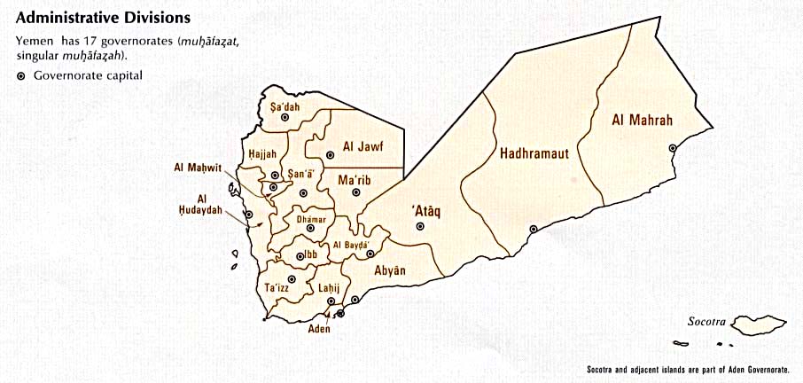
Yemen
[edit]-
 Northern Yemen
 -
 Southern Yemen
 -
 Orthographic projection of Middle East in the 90's


- Article(s)
- South Yemen and Yemen Arab Republic.
- Request
- Hi. I need two svg orthographic projections for South Yemen and Yemen Arab Republic. Both should have etheir northern or southern Yemen in light green, as territory claimed. Like for Ba'athist Syria for example. CC @Abo Yemen:. -- Panam2014 (talk) 12:59, 10 January 2026 (UTC)
- Thanks for the ping. I would also like to request a map of South Yemen showing the w:Kamaran island being part of it, per w:South Yemen#Territorial changes 𐩣𐩫𐩧𐩨 Abo Yemen (𓃵) 13:02, 10 January 2026 (UTC)
- Source: NYT 𐩣𐩫𐩧𐩨 Abo Yemen (𓃵) 17:00, 12 January 2026 (UTC)
- Thanks for the ping. I would also like to request a map of South Yemen showing the w:Kamaran island being part of it, per w:South Yemen#Territorial changes 𐩣𐩫𐩧𐩨 Abo Yemen (𓃵) 13:02, 10 January 2026 (UTC)
- Discussion
- To avoid WP:CIRCULAR, I suggest listing reliable sources that show both territories. M.Bitton (talk) 16:41, 12 January 2026 (UTC)
- Hi @AAEexecutive, you'll need to place this under a separate request, as your map isn't relevant to this specific discussion. There are instructions at the top of the page on how to go about this.
- Best,
- CSGinger14 (talk) 18:05, 13 January 2026 (UTC)
- I reverted their edit. M.Bitton (talk) 18:21, 13 January 2026 (UTC)
- The misplaced message link. @AAEexecutive, I requested an SVG version at Wikimedia Commons: Commons Graphic lab link. I thought they may be more familiar with SVG language conversion. Commander Keane (talk) 03:19, 14 January 2026 (UTC)
- @Abo Yemen as you are presumably aware North/South Yemen's borders were always contested and often not properly defined or in a state of flux. What year's boundaries do you want? I have a number of sources:
- https://www.cia.gov/readingroom/docs/CIA-RDP85T00314R000100010001-0.pdf (p18)
- https://commons.wikimedia.org/wiki/File:South_Yemen-CIA_WFB_Map.png
- https://users.ox.ac.uk/~metheses/Ismail%20Thesis.pdf
- https://maps.lib.utexas.edu/maps/atlas_middle_east/yemen_divisions.jpg
- https://www.cia.gov/readingroom/docs/CIA-RDP89S01450R000500500001-7.pdf (p10)
- https://www.cia.gov/readingroom/docs/CIA-RDP88T00096R000800980002-6.pdf (p11)
- Arabian boundary disputes Schofield (vol 20)
- Saudi-Yemeni relations : domestic structures and foreign influence Gregory
- – Isochrone (talk) 00:11, 28 January 2026 (UTC)
- @Abo Yemen as you are presumably aware North/South Yemen's borders were always contested and often not properly defined or in a state of flux. What year's boundaries do you want? I have a number of sources:
- The misplaced message link. @AAEexecutive, I requested an SVG version at Wikimedia Commons: Commons Graphic lab link. I thought they may be more familiar with SVG language conversion. Commander Keane (talk) 03:19, 14 January 2026 (UTC)
- I reverted their edit. M.Bitton (talk) 18:21, 13 January 2026 (UTC)
Request: File:State positions Iraq war.svg Please correct the missing content in this map.
[edit]-
 See request below.

- Article(s)
- Iraq–European Union relations#Divisions in the approach to 2003 Iraq war, International reactions to the prelude to the Iraq War and Legality of the Iraq War
- Request
- I found that there were some missing in this map. Six countries including Luxembourg, the Republic of Ireland, Cyprus, Armenia, Burma and Cambodia, together with Greece, France, Greece, Russia, China, Vietnam and other countries, opposing the Iraq War. I suggest changing the colors of the six countries including Luxembourg, the Republic of Ireland, Cyprus, Armenia, Burma and Cambodia to the same blue color as those of Germany, France, Greece, Russia, China and Vietnam. Thanks. At the same time, Ukraine should be changed to gray, and the Solomon Islands and Rwanda should be changed to yellow like Japan. Other contents remain unchanged. -- Boston Mayflower (talk) 06:47, 13 January 2026 (UTC)
- Discussion
- Hi Boston Mayflower, do you have reliable sources to support these changes? I don't see those countries mentioned in the articles you linked, except Ireland and Ukraine which are mentioned in the international reactions article, which supports their current colors. Justin Kunimune (talk) 00:47, 14 January 2026 (UTC)
Request: Tatannuaq
[edit]- Article(s)
- Tatannuaq
- Request
- There is currently an FAC for this article and a commentator mentioned that a map of locations should be included. Afterwards, my co-nominator created the map currently in the article, but it is too large and the cropping of the map makes it hard to determine where these locations are in Canada. We are hoping someone can create a better map to use in the article. -- Z1720 (talk) 01:10, 15 January 2026 (UTC)
- Discussion
- I just want to put in a good word for this request. I'm the reviewer who suggested coming here. I could build something with an OSM-connected mapframe, but it would look like somebody with no artistic skill built it with mapframe. For a FA-level article, I think we need to go the extra distance and get somebody custom-tailored by an artist who really knows they way around cartography. RoySmith (talk) 19:48, 18 January 2026 (UTC)
- Hi @RoySmith and @Z1720, do you still want a map for this? If so, what specific components do you want and what do you want highlighted on the map? – Isochrone (talk) 23:12, 27 January 2026 (UTC)
- Hi @Isochrone thanks for taking a look at this. I've already gone ahead and created three maps for that article using {{maplink}}, which is pretty much the limit of my skills. I think we're at the stage where the maps I made are good enough to satisfy WP:FACR but I could see ways they could be improved for the future.
- The first map, in "Early life" is the simplest since it just shows the three locations discussed in the adjoining text. I think it could be improved by having the locations labeled right on the map instead of having to match up the numbers in the caption. The other two maps ("Coppermine expedition" and "Mackenzie River expedition") share the problem of having to look up numbered items in the caption, but in addition, could benefit from having the dates when the expeditions reached those locations.
- And, this being Canada, I think they would all benefit from a better map projection. As far as I know, {{maplink}} can only do Mercator which is not wonderful at these latitudes. RoySmith (talk) 23:31, 27 January 2026 (UTC)
- So are we thinking perhaps a static map instead? Or something that somehow fits into the existing maplink framework? (As you note maplink only supports web Mercator). – Isochrone (talk) 23:34, 27 January 2026 (UTC)
- I'm guessing a set of hand-drawn static maps will give us the best result. I only used maplink because it's the technology I know (when the only tool you have is a hammer ...) RoySmith (talk) 23:38, 27 January 2026 (UTC)
- I can't guarantee it but I'll have a look tomorrow – thanks – Isochrone (talk) 23:55, 27 January 2026 (UTC)
- I'm guessing a set of hand-drawn static maps will give us the best result. I only used maplink because it's the technology I know (when the only tool you have is a hammer ...) RoySmith (talk) 23:38, 27 January 2026 (UTC)
- So are we thinking perhaps a static map instead? Or something that somehow fits into the existing maplink framework? (As you note maplink only supports web Mercator). – Isochrone (talk) 23:34, 27 January 2026 (UTC)
- Hi @RoySmith and @Z1720, do you still want a map for this? If so, what specific components do you want and what do you want highlighted on the map? – Isochrone (talk) 23:12, 27 January 2026 (UTC)
Please separate Halabja from Sulaymaniyah if possible
[edit]-
 Map of Iraq's Governorates
 -


Article(s): Map featuring Iraq's Governorates:
- en:Politics of Iraq
- en:Governorates of Iraq
- en:Administrative divisions of Iraq
- en:Iraq
- en:Portal:Iraq/Governorates Image Map
- en:User:Kharbaan Ghaltaan/Iraq
- en:User:Kharbaan Ghaltaan/Iraq !!
Map containg the results of the 2024 Kurdistan Region results:
- Request
- Currently, if you download both of these two SVG images that I have provided, you would notice that the Halabja Governorate is actually apart of the Sulaymaniyah Governorate. Instead, I would like for Halabja to be separated from Sulaymaniyah and be distinct parts of each other in said SVG file.
- Do note that I copied this request from right here as I didn't see anybody comment on my request. I'm hoping that this time that someone would come here to actually fufill my suggestion on this one. GuesanLoyalist (talk) 12:39, 18 January 2026 (UTC)
![]() Bumping thread. GuesanLoyalist (talk) 06:09, 20 January 2026 (UTC)
Bumping thread. GuesanLoyalist (talk) 06:09, 20 January 2026 (UTC)
![]() Bumping thread. GuesanLoyalist (talk) 05:54, 27 January 2026 (UTC)
Bumping thread. GuesanLoyalist (talk) 05:54, 27 January 2026 (UTC)
- Graphist opinion(s)
Typos on a color legend
[edit]-
 Global effects of the 1988–1992 revolutions

- Article(s)
- Request
Make the following typographical corrections:
- Socialims → Socialism
- Economical liberalization → Economic liberalization
- Startd → started
I would also suggest modifying the text in the legend so that it consistently uses sentence case.
- Discussion
– MrPersonHumanGuy (talk) 19:30, 18 January 2026 (UTC)
British Empire map
[edit]-
 Map of the British Empire to be edited
 -
 Map of the Spanish Empire that illustrates what I mean


- Article(s)
- British Empire
- Request
- Please make territories lost before 1900 (before the maximum territorial extent) visually distinct in File:The_British_Empire_5.png. These are the Thirteen Colonies, Florida, Mosquito Coast, Ionian Islands, Heligoland, and Minorca. Thanks in advance! -- TompaDompa (talk) 23:09, 18 January 2026 (UTC)
- Discussion
Request: Map of the Nile river
[edit]-
 Good: Correct area, topo coloring, absence of text labels, presence of country boundaries, drainage basin shown. Bad: border, low resolution.
 -
 Good: Correct area; Bad: border, low resolution, drainage basin shown.; flat coloring.
 -
 Good: correct area; Bad: textual labels; River basin not delineated (with color change).


_-_OpenStreetMap_27_December_2025.png)
_-_OpenStreetMap_27_December_2025.png?lang=en)
- Article(s)
- Nile River
- Request
- I'm working on the Nile River article, planning to get it to WP:Featured Article status. Of course, a great map is required. I've hunted in Wiki Commons, but cannot find a decent map. The closest I can find are the three images displayed above ... but none of them are great.
I only need one map. I'm displaying three example maps above as examples of "close, but not great".
The desired map would be similar to the first (left) map shown above, with these improvements:
- Higher resolution: about 1,000 x 3,000 pixels
- Eliminate the border region around the perimeter (with lat/long numbers) ... not needed
Things about the first map that are great and should be retained:
- Topographic (elevation) coloring inside the Nile basin
- Emphasize the Nile River drainage basin by changing color scheme inside/outside the basin
- Nile river (and its lakes) must prominently displayed in a bold blue color
- No textual labels at all on the map
- National boundary lines (should be fairly faint)
Things about the first map that _could_ be changed if it helps the graphist/cartographer:
- Okay to change the topo/elevation coloring to another scheme
- Okay to eliminate the elevation/topo legend/key
Thanks so much for any help you can provide!!! -- Noleander (talk) 04:23, 28 January 2026 (UTC)
- Discussion