
Wikipedia:Graphics Lab/Map workshop
The Graphics Lab is a project to improve the graphical content of the Wikimedia projects. Requests for image improvements can be added to the workshop pages: Illustrations, Photographs and Maps. For questions or suggestions one can use the talk pages: Talk:Graphics Lab, Talk:Illustrations, Talk:Photographs and Talk:Maps.
This specific page is the requests page for the Map workshop. Anyone can make a request for a map to be created or improved for a Wikipedia article. The standard format for making a request is shown below, along with general advice, and should be followed.
You are encouraged to share information and request advice from others. Also see possible conventions toolbox, map tutorials and topographic map tutorials.
| Advice to requesters |
|---|
|
What do we do?
|


| If you have completed work and not received a reply you may use the {{GL Map reply}} template to inform the requester. |
| Map makers and other visitors to the Graphics Lab may be interested in the RSS feed of changes to this page. You may find it here. |
| See also our sister Map workshop at Commons and the WikiProject Maps |
| Result | Code | Usage |
|---|---|---|
{{resolved}} ~~~~
|
Mark a thread as resolved and request archiving | |
{{subst:bump}}
|
Delay automatic archiving of a section for 30 days | |
{{I take|~~~~}}
|
When you'll be working on the request | |
{{Done}} ~~~~
|
When the request is done |
This page is automatically archived by ClueBot III. | |
| This page has a backlog that requires the attention of willing editors. Please remove this notice when the backlog is cleared. |
Kuching
-
 1
1 -
 2
2 -
 3
3


- Article(s)
- Kuching
- Location Map
- Request
- Needs update base on 2016 map angys (Talk Talk) 20:45, 19 December 2017 (UTC)
- Graphist opinion(s)
ABC angys (Talk Talk) 15:04, 20 January 2018 (UTC)
Districts map for Klang and Hulu Selangor
- Article(s)
- Klang District
- Hulu Selangor District
- Request
- I would like to ask somebody to do a favor to create a district locator map for that two districts as other districts already have it's locator map e.g. Petaling angys (Talk Talk) 13:26, 24 December 2017 (UTC)
- Graphist opinion(s)
Same as above. --Goran tek-en (talk) 19:20, 3 January 2018 (UTC)
- OK, this one is easier to know.@Goran tek-en: The Hulu Selangor and Klang was labelled as Number 3 and 4. This is an example of the district locator map for Petaling District angys (Talk Talk) 05:43, 10 February 2018 (UTC)
Districts locator map for Perak
- Article(s)
- Hulu Perak District
- Kinta District and 10 more
- Request
- I would like to ask somebody to do a favor to create a district locator map for that 12 districts by refering this angys (Talk Talk) 05:43, 10 February 2018 (UTC)
- Graphist opinion(s)
Cabinda

- Article(s)
- Cabinda
- Request
- new version please, no frame and update Zaire… -- Kintetsubuffalo (talk) 04:32, 8 January 2018 (UTC)
- Graphist opinion(s)
Commons:file:Cabinda map-fr.svg is a svg version and is preferred over the bitmap version and easier to edit. What do you mean by "update Zaire" you have to show us border, map or something else otherwise it's impossible to know. This is your subject, mostly we graphic workers have no knowledge of the requester's favorit topic, thanks. --Goran tek-en (talk) 15:45, 29 January 2018 (UTC)
- I think they mean, it is no longer called Zaire, but DRC. 67.245.208.219 (talk) 16:29, 3 February 2018 (UTC)
- Goran tek-en, the IP is right, they changed to Democratic Republic of the Congo 20 years ago.--Kintetsubuffalo (talk) 09:39, 8 February 2018 (UTC)
- Kintetsubuffalo But you still hasen't given any information as I asked for above. --Goran tek-en (talk) 18:16, 11 February 2018 (UTC)
- Goran tek-en Yeah, if you could make an English version of File:Cabinda map-fr.svg, that'd be great!--Kintetsubuffalo (talk) 03:00, 12 February 2018 (UTC)
- Kintetsubuffalo If you provide the translation French - English I will "Take this". --Goran tek-en (talk) 16:30, 12 February 2018 (UTC)
- Goran tek-en here goes, all the French that needs changed:
- Goran tek-en Yeah, if you could make an English version of File:Cabinda map-fr.svg, that'd be great!--Kintetsubuffalo (talk) 03:00, 12 February 2018 (UTC)
- Kintetsubuffalo But you still hasen't given any information as I asked for above. --Goran tek-en (talk) 18:16, 11 February 2018 (UTC)
- Goran tek-en, the IP is right, they changed to Democratic Republic of the Congo 20 years ago.--Kintetsubuffalo (talk) 09:39, 8 February 2018 (UTC)
- Democratic Republic of the Congo
- Atlantic Ocean
- Bay of Cabinda
- bottom column 1
- airports (runways over 1370m)
- capital of Cabinda
- cities
- bottom column 2
- national borders
- border of Cabinda
- railways
- roads
--Kintetsubuffalo (talk) 10:26, 15 February 2018 (UTC)
Mid-South (region)
-
A map of the article's description. Not difficult, just need to colour some parts of the U.S.
- Article(s)
- Mid-South (region)
- Request
- "consisting of West Tennessee, North Mississippi, Southern Missouri, Western Kentucky, Central, Northeast, and Northwest Arkansas, and Northwest Alabama. Southern Illinois is sometimes included in this region." -- WhatsUpWorld (talk) 18:56, 20 January 2018 (UTC)
- Graphist opinion(s)
Map of ISIS-related insurgency
- Article(s)
- Islamic State of Iraq and the Levant
- Request
- In Talk:Islamic_State_of_Iraq_and_the_Levant#Territorial_control_map, some editors suggested replacing the article infobox territorial control map with a map for all ISIS-related insurgencies, historical and current, in order to better reflect the subject because of the decreasing area of control they have on Iraq and Syria. AS it doesn't seems like such map exists in the article so I would like to request for creation of such a map. -- C933103 (talk) 03:28, 22 January 2018 (UTC)
- Graphist opinion(s)
Legal status of electronic cigarettes in Europe
- Article(s)
Regulation of electronic cigarettes
- Request
- The map given for Europe really needs to be fixed or replaced with a new map. Scotland on the map is totally messed up and Britain is positioned further east than it should be. Britain on the map is shown to have a physical land border with the Netherlands, which of course is totally inaccurate. If anyone could please either fix or replace this map it would be much appreciated. Thanks. Helper201 (talk) 11:59, 23 January 2018 (UTC)
- Graphist opinion(s)
![]() Done Ikonact (talk) 14:36, 23 January 2018 (UTC)
Done Ikonact (talk) 14:36, 23 January 2018 (UTC)
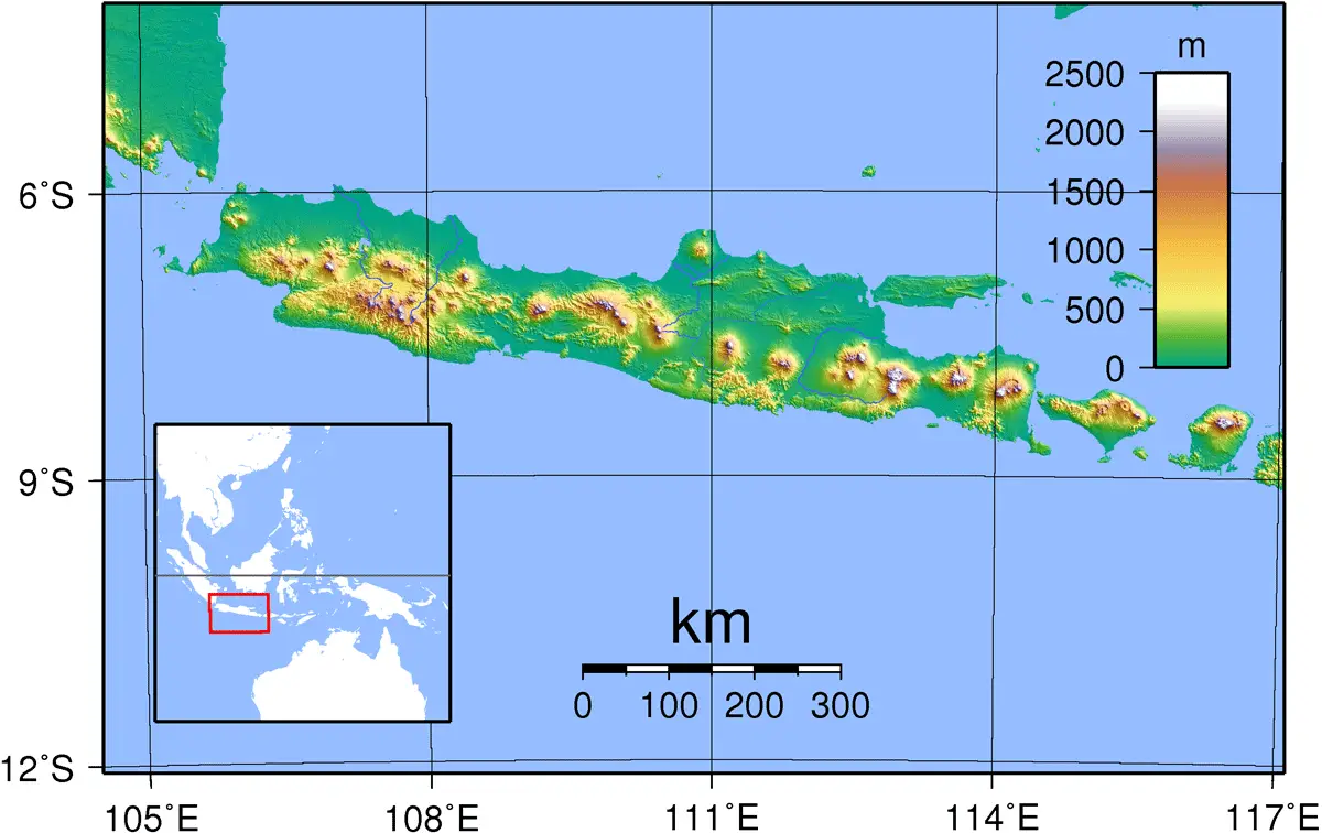
Topographic map of Java
- Article(s)
- Generally dozens of articles, e.g. all in category:Volcanoes of Java, category:Mountains of Java etc.
- Request
- We have topographical maps of plenty of Indonesian islands here on EN Wiki. I couldn't find the topographical map of Java though. Since we have plenty of geographical articles about Java, it would be good to have the topographical map as well, not only the plain administrative one. -- Darwinek (talk) 12:30, 26 January 2018 (UTC)
- Graphist opinion(s)
![]() Request taken by Goran tek-en (talk) 14:19, 27 January 2018 (UTC).
Request taken by Goran tek-en (talk) 14:19, 27 January 2018 (UTC).
- @Darwinek: Draft. I think the rivers becomes to dominating but then I will have to do it without them all together, give me feedback, thanks. Please ping me. --Goran tek-en (talk) 17:42, 27 January 2018 (UTC)
- @Goran tek-en: I think it looks great actually, I don't have a feeling of the rivers being too dominating in the map. - Darwinek (talk) 17:36, 29 January 2018 (UTC)
- @Darwinek: That's great, I will need the following;
- Name of the file - Java Relief Map
- Description - Topographic location map of Java, Indonesia
- Category/ies at commons
Maps of Java, Topographic maps of Indonesia and SVG maps of Indonesia
- to be able to upload it at commons. --Goran tek-en (talk) 18:02, 30 January 2018 (UTC)
- @Goran tek-en: Please see my answers above. One question from me, can your map be used as a locator map, e.g. in infoboxes? - Darwinek (talk) 18:54, 30 January 2018 (UTC)
- @Darwinek: That's great, I will need the following;
- @Goran tek-en: I think it looks great actually, I don't have a feeling of the rivers being too dominating in the map. - Darwinek (talk) 17:36, 29 January 2018 (UTC)
@Darwinek: Now you can find it here Commons:file:Java Relief Map.svg.
I have never done a locator map in a infobox but what I have seen you just link to the map you want as a base. If it doesn't work just ping me and we will find out.
If you are happy with this please put the code {{tl|resolved|1=~~~~}} on this request so it can be archived, thanks. ![]() Done --Goran tek-en (talk) 19:36, 30 January 2018 (UTC)
Done --Goran tek-en (talk) 19:36, 30 January 2018 (UTC)
- For it to work in the location map template the relief map needs to have the same projection and extents as the base location map, i.e. lat/long with 101% N/S stretching and 104.8°E, 4.5°S, 116.5°E, 10.7°S. @Goran tek-en: Can you adjust it? (Or, alternatively, create a new location map that matches your relief map?) – Joe (talk) 08:11, 31 January 2018 (UTC)
- @Joe Roe: I have updated the area now Commons:file:Java Relief Map.svg, don't forget the resolved code for this request. --Goran tek-en (talk) 18:32, 31 January 2018 (UTC)
Canadian national parks
-
 Vectorize and update

Article(s):
- List of National Parks of Canada, related content
- Request
- Please update File:Canadian National Parks Location.png, which was last updated in 2006 by an editor who now seems to be retired. I suppose updating to svg format would also be desirable. Data is available from Canada's Open Government portal here, although I don't know if this is a desirable format; better data might be available here but I don't know how to read these files. The present image shows only National Parks and Park Reserves, it would be nice if there could also be a map with National Marine Conservation Areas (same data, I think) and one which shows both, for use in different places. Thanks! Ivanvector (Talk/Edits) 15:44, 27 January 2018 (UTC)
- Graphist opinion(s)
How to change projection
Could you explain me how can I change the projection of any SVG-map? The problem is I'm planning to work with historical (I mean old) maps and they often have very particular projection. So I need some soft or smth that can convert any random-projection-SVG-map into a standard-projection one and vice versa. I hope you understand my problem and pain and could give me some tips. --Yakiv Gluck (talk) 11:59, 6 February 2018 (UTC)
- SVG has an operation "transform" which can perform any specified linear mapping to any image. This includes translations, rotations, and shears. It should be good enough for most purposes as long as the map only covers a small proportion of the earth's surface. Specifying what transformation you want may be difficult, particularly if you start with "any random-projection". Something that might help you, and maybe even exists, is software that, for a set of tie-points (at least three, ideally a few more), accepts their co-ordinates in your map and in the real world, and calculates the transform matrix that will give you the best linear mapping.
- If you do use such a technique, I recommend that your transformed maps should include a comment containing a link to the original untransformed SVG, a list of the tie-points used and their coordinates, and the transform function applied. Maproom (talk) 16:57, 6 February 2018 (UTC)
Guatemala - Belize Territorial Dispute
.svg?lang=en)

- Article(s)
- Guatemala
- Request
- Perhaps someone could edit the above map of Guatemala to highlight the territory it claims from Belize (above-right) in light green? After all, it would make it consistent with other such Wikipedia maps displaying countries with territorial disputes (e.g. India/Pakistan, Russia/Ukraine, Egypt/Sudan etc.). User:Snow Lion Fenian
- Graphist opinion(s)
Saint Pierre and Miquelon
- Article(s)
- Saint Pierre and Miquelon
- Request
- please create closeup map of the islands in relation to Newfoundland. The article has two long-distance maps which show them as specks… -- Kintetsubuffalo (talk) 09:35, 8 February 2018 (UTC)
- Graphist opinion(s)
Commonwealth Games - Birmingham & Durban

- Article(s)
- Commonwealth Games
- Request
- Could someone please change South Africa back to red and remove Durban from the map, as it is no longer scheduled to host the 2022 Commonwealth Games (after all, as far as I'm aware, Montreal was supposed to host the cancelled 1942 Games, yet isn't marked as such either). Also, since the city of Birmingham, England, has been chosen as the new hosts of the 2022 Games, perhaps you could also mark them as such. Thanks. User:Snow Lion Fenian
- Graphist opinion(s)
Independence from Britain


- Article(s)
- List of countries that have gained independence from the United Kingdom
- Request
- Okay, I've noticed a few inaccuracies with the above-left map that should probably be fixed:
1) The flag of the Dominican Republic is incorrectly shown for Dominica (above-centre), a completely different country.
2) Saint Vincent and the Grenadines gained independence in 1979, not 1931.
3) There's no arrow linking the flag of Myanmar to its respective flag.
4) The flag of Malta is wrongly shown to be linked to the Balearic Islands, not at Malta itself.
5) Nauru gained independence in 1968, not 1957.
6) The Maldives gained independence in 1965, not 1982.
7) The flags of Tonga and Tuvalu are actually shown pointing to Fiji, and the flag of Fiji itself is linked to Vanuatu (the actual locations of said countries are provided on the above-right map).
8) Papua New Guinea gained independence from Australia in 1975, not Britain, hence it should be removed from the map (otherwise you'd have to include all other countries that gained independence from former British holdings, such as Namibia, Bangladesh, South Sudan, etc.).
Thanks. User:Snow Lion Fenian
- Graphist opinion(s)
Indonesia demographics

- Article(s)
- Indonesia demographics
- Request
- can someone please make the svg display at higher resolution? At present largest magnification it's nigh illegible… -- Kintetsubuffalo (talk) 09:59, 12 February 2018 (UTC)
- Graphist opinion(s)
- I've made the SVG resizable, that's very easy to do (I just deleted the beginning of line 5 that says "width="1190.551px" height="500.975px" "). But you'll need a large screen to get the SVG to render at a size that makes the smallest text readable; and it still uses a rather nasty font. Maproom (talk) 14:55, 12 February 2018 (UTC)
Lima Group map
- Article(s)
- Lima Group
- Request
- Was wondering if someone could make a map of member states of the Lima Group. Maybe they could use this map?----ZiaLater (talk) 21:22, 15 February 2018 (UTC)
- Graphist opinion(s)
Repartition of Ireland
.jpg?lang=en)
- Article(s)
- Repartition of Ireland
- Request
- This map would be significantly more useful if it had a clear border delineation between the Republic of Ireland and Northern Ireland. Since there is no clear border, a reader would have to refer to a secondary map to know which counties are Northern Ireland and which are Republic of Ireland. As a secondary and minor issue, it seems counter-intuitive to color the Loyalist/Protestant areas green, since that color is traditionally associated with Catholics/Republicans. The most literal coloration would be to have the RoI and Catholic areas of NI be green, and Protestant be orange, but honestly any scheme which doesn't label the Loyalists/Protestants as green would be better than the current coloration. -- MatthewVanitas (talk) 09:40, 16 February 2018 (UTC)
- Graphist opinion(s)
I see four things that could usefully done to this image:
- Convert it from .JPG to .PNG
- Make some of the county boundaries thicker, to show the current international border
- Use a more appropriate colour for the Protestant population
- Copy or move it to Wikimedia Commons
I'll wait a while to read people's comments before doing anything. Maproom (talk) 10:05, 16 February 2018 (UTC)
- On the second map: Most valuable thing missing is to mark that area that actually changes. SVG would be better than PNG for this.
- More problematically, who proposed the boundaries of the 2nd map? The first map showing census data (if accurate) is fine, but the second is dubious.--Nilfanion (talk) 21:55, 16 February 2018 (UTC)
Libyan Civil War map
- Article(s)
- Libyan Civil War (2014-present)
- Request
- Can someone please update the map based on the template? it had been a long time since last time the map updated. --LIBYAĐRA☪OON: 02:39, 17 February 2018 (UTC)