
Sagaing
Sagaing
စစ်ကိုင်းမြို့ Jayapura | |
|---|---|
City | |
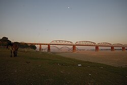
 The Yadanabon Bridge on the Irrawaddy | |
 Sagaing Location in Burma | |
| Coordinates: 21°52′56″N 95°58′43″E / 21.88222°N 95.97861°E | |
| Country | Myanmar |
| Division | |
| Population (2014) | 307,194 |
| • Religions | Buddhism |
| Time zone | UTC+6.30 (MST) |
Sagaing (Burmese: စစ်ကိုင်းမြို့; MLCTS: cac kuing: mrui., pronounced [zəɡáɪɰ̃ mjo̰]) is the capital of the Sagaing Region of Myanmar. It is located on the Irrawaddy River, 20 km (12 mi) to the south-west of Mandalay on the opposite bank of the river. Sagaing, with its numerous Buddhist monasteries, is an important religious and monastic centre. The pagodas and monasteries crowd the numerous hills along the ridge running parallel to the river. The central pagoda, Soon U Ponya Shin Pagoda, is connected by a set of covered staircases that run up the 240 m (790 ft) hill.
Today, with about 70,000 inhabitants, the city is part of Mandalay metropolitan area, home to more than 1,022,000 inhabitants as of 2011. It is a frequent tourist destination for day trippers, usually as part of the "three former capitals" itinerary alongside Amarapura and Innwa.
The city is home to five institutions of higher learning: the Sagaing Institute of Education, Sagaing Education College, Sagaing Technological University, Sagaing University of Co-operative and Management, and Sagaing University. The latter was established on 11 February 2012; it is located in Pakatoe Quarter, Sagaing Township, with an area of 121.55 ha (300.35 acres).
Name
[edit]The classical name of Sagaing is Zeyapura (ဇေယျာပူရ; Pali: Jayapura), which literally translates to "city of victory."[1]
History
[edit]Sagaing was the capital of Sagaing Kingdom (1315–1364), one of the minor kingdoms that rose up after the fall of Pagan dynasty, where one of Thihathu's sons, Athinkhaya, established himself.[2]: 227 During the Ava period (1364–1555), the city was the common fief of the crown prince or senior princes. During the reign of King Naungdawgyi, Sagaing briefly became the royal capital between 1760 and 1763.
On 8 August 1988, Sagaing was the site of mass public protests in support of the 8888 Uprising, which were brutally crushed by a massacre in which around 300 civilians were killed by local police forces.[3]
As the epicentre of the 7.7-magnitude 2025 Sagaing earthquake, the city suffered extensive damage to its buildings and infrastructure alongside neighbouring Mandalay. The Ava Bridge, one of two road-rail bridges connecting Sagaing to Mandalay, has partially collapsed.[4]
Climate
[edit]Located in the rain shadow of the Arakan Mountains, Sagaing has a borderline hot semi-arid climate (Köppen BSh) just short of a tropical savanna climate (Aw). The city receives less than a third of the rainfall that Chittagong has at a similar latitude on the Bay of Bengal. Unlike most monsoonal semi-arid climates, the rainy season is relatively long at around five to six months, while variability and extreme monthly and daily rainfalls are much lower than usual with this type of climate.[5]
| Climate data for Sagaing (1991–2020) | |||||||||||||
|---|---|---|---|---|---|---|---|---|---|---|---|---|---|
| Month | Jan | Feb | Mar | Apr | May | Jun | Jul | Aug | Sep | Oct | Nov | Dec | Year |
| Record high °C (°F) | 34.5 (94.1) |
37.7 (99.9) |
42.0 (107.6) |
45.5 (113.9) |
45.2 (113.4) |
40.5 (104.9) |
40.0 (104.0) |
38.4 (101.1) |
38.8 (101.8) |
38.0 (100.4) |
37.0 (98.6) |
36.5 (97.7) |
45.5 (113.9) |
| Mean daily maximum °C (°F) | 29.5 (85.1) |
32.6 (90.7) |
36.4 (97.5) |
38.3 (100.9) |
36.0 (96.8) |
34.4 (93.9) |
33.7 (92.7) |
33.0 (91.4) |
33.2 (91.8) |
32.8 (91.0) |
31.4 (88.5) |
29.2 (84.6) |
33.4 (92.1) |
| Daily mean °C (°F) | 22.0 (71.6) |
24.5 (76.1) |
28.6 (83.5) |
31.4 (88.5) |
30.9 (87.6) |
30.3 (86.5) |
29.9 (85.8) |
29.5 (85.1) |
29.4 (84.9) |
28.5 (83.3) |
25.9 (78.6) |
22.6 (72.7) |
27.8 (82.0) |
| Mean daily minimum °C (°F) | 14.5 (58.1) |
16.5 (61.7) |
20.8 (69.4) |
24.6 (76.3) |
25.8 (78.4) |
26.2 (79.2) |
26.2 (79.2) |
25.9 (78.6) |
25.5 (77.9) |
24.2 (75.6) |
20.4 (68.7) |
16.0 (60.8) |
22.2 (72.0) |
| Record low °C (°F) | 10.7 (51.3) |
11.0 (51.8) |
13.5 (56.3) |
18.7 (65.7) |
19.3 (66.7) |
20.5 (68.9) |
20.0 (68.0) |
20.5 (68.9) |
19.2 (66.6) |
16.7 (62.1) |
14.0 (57.2) |
12.3 (54.1) |
10.7 (51.3) |
| Average precipitation mm (inches) | 5.0 (0.20) |
3.5 (0.14) |
5.4 (0.21) |
40.6 (1.60) |
148.6 (5.85) |
82.1 (3.23) |
66.2 (2.61) |
126.2 (4.97) |
158.9 (6.26) |
134.3 (5.29) |
28.4 (1.12) |
4.8 (0.19) |
804.0 (31.65) |
| Average precipitation days (≥ 1.0 mm) | 0.6 | 0.4 | 0.6 | 3.2 | 9.5 | 6.8 | 5.9 | 9.3 | 11.0 | 8.5 | 2.6 | 0.7 | 59.0 |
| Source 1: World Meteorological Organization[6] | |||||||||||||
| Source 2: Meteomanz(record since 2014)[7] | |||||||||||||
People
[edit]- Sithu Kyawhtin, King of Ava (1552–1555)
- Zhu Youlang, Prince of Gui, last Ming Dynasty claimant to China, lived in exile at Sagaing in 1661
- Maurice Collis, author of Trials in Burma, district commissioner of the Sagaing district in 1928
- Tom Mitford, brother of the Mitford Sisters, was killed while serving with the Devonshire Regiment at Sagaing in 1945.
- Zaw Hlaing Thein, politician
Places of interest
[edit]The Kaunghmudaw Pagoda (Burmese: ကောင်းမှုတော် ဘုရား [káʊɴ m̥ṵ dɔ̀ pʰəjá]; Yaza Mani Sula Kaunghmudaw (ရာဇမဏိစူဠာ ကောင်းမှုတော်); Pali: Rājamaṇicūḷā) is a large pagoda on the northwestern outskirts of Sagaing.
Images
[edit]-
 Sagaing Hill
 -
 Irrawaddy River from Sagaing Hill, Sagaing
 -
 Pagodas
 -
 Buddhist monks
 -
 Viewpoint at Sagaing Hill
 -
 Pagodas dotting Sagaing's landscape
 -
 U Min Thonze cave
 -
 Sone Oo Pone Nya Shin Pagoda, Sagaing Hill
 -
 U Min Thonze Pagoda
 -
 The Ava and Yadanabon bridges, connecting Sagaing and Mandalay
 -
 Panoramic view from top of Sagaing Hill


See also
[edit]References
[edit]- ^ Hardiman, John Percy (1901). Gazetteer of Upper Burma and the Shan States. Superintendent, Government Printing, Burma.
- ^ Coedès, George (1968). Walter F. Vella (ed.). The Indianized States of south-east Asia. trans.Susan Brown Cowing. University of Hawaii Press. ISBN 978-0-8248-0368-1.
- ^ Irrawaddy article 1997 Archived 2010-10-04 at the Wayback Machine
- ^ Mehrotra, Vani (28 March 2025). "Under-Construction Skyscraper In Bangkok Collapses After 7.7-Magnitude Earthquake Hits Myanmar". CNN-News18. Retrieved 28 March 2025.
- ^ See Camberlin, Pierre (2010). "More variable tropical climates have a slower demographic growth" (PDF). Climate Research. 41: 157–167. Bibcode:2010ClRes..41..157C. doi:10.3354/cr00856.
- ^ "World Meteorological Organization Climate Normals for 1991–2020". World Meteorological Organization. Retrieved 16 October 2023.
- ^ "NAJAF - Weather data by month". meteomanz. Retrieved 28 June 2024.
| International | |
|---|---|
| National | |