
Wikipedia:Graphics Lab/Map workshop/Archive/Feb 2014
Stale
Resolved
Map of the Golan Heights
-
 This map should be redrawn.
 -
 It should be based on this.
 -
 Map by CIA.
 -
 Map by UN but heavily modified. The original can be seen here.
 -
 Finished map


Article(s): Geography of Jordan, Outline of Jordan, United Nations Security Council Resolution 1351 and Water conflict in the Middle East and North Africa.
Request:
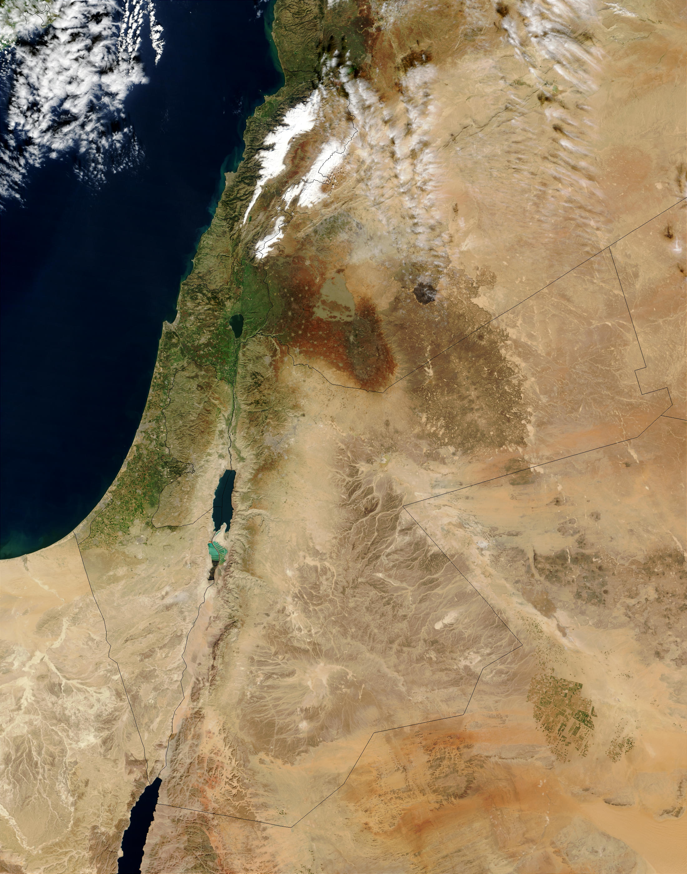
- The map by NASA shows the Golan Heights as a part of Israel. The borders were barely visible first but they were emphasized by an user. I am requesting that the lines showing the Golan Heights should be based on File:Syria location map3.svg. Thank you. -- IRISZOOM (talk) 20:39, 1 February 2014 (UTC)
Graphist opinion(s):
- Comment: This is a potentially difficult task from an NPOV aspect - according to the Golan Heights article there are different definitions of what is included in the area. The map lab doesn't make decisions on matters like that - do you have a consensus for the change? Best, ► Philg88 ◄
 talk 21:12, 1 February 2014 (UTC)
- This is about political borders. The Golan Heights is occupied by Israel. There is a consensus about that, which the article and maps show. Here is another map (BBC). File:Golan heights rel89-orig.jpg is another one by CIA.
- In Template talk:Location map Syria#Restoration of location map, there was a consensus:
- Closing per a request at WP:ANRFC. Consensus was that the different color, hatched version (i.e. File:Syria location map3.svg) should be used in light of events related to the occupation of this particular region of Syria. However, Huon's comments regarding context are worth careful consideration. Articles not closely related these events may not require a map version with a different color. It is, therefore, worthwhile to discuss usage of File:Syria location map3.svg on a case-by-case basis if there is any significant objection to its relevance on Syria-related articles. I, JethroBT drop me a line 03:11, 27 September 2013 (UTC)
- And this is not about using a specific colour but just mark the lines correctly. --IRISZOOM (talk) 23:44, 1 February 2014 (UTC)
Comment: OK, that's good news. The bad news is that the original source map from NASA has these lines and because it is in jpg format there is no way to remove them without making a mess of the map. Is there an alternative (unmarked) topographic map that you know of over which the borders from Syria location map3.svg can be overlaid? Best, ► Philg88 ◄ ![]() talk 12:58, 2 February 2014 (UTC)
talk 12:58, 2 February 2014 (UTC)
- Wouldn't it be possible to emphasize the lines on the original map as done before but using dotted lines on the Golan Heights and then overlay the missing ones? Then it wouldn't matter that the original lines are not removed because they are barely visible and are going to be overwritten. --IRISZOOM (talk) 20:21, 2 February 2014 (UTC)
![]() Request taken. Let me see what I can come up with. ► Philg88 ◄
Request taken. Let me see what I can come up with. ► Philg88 ◄ ![]() talk 08:39, 3 February 2014 (UTC)
talk 08:39, 3 February 2014 (UTC)
- Comment: Please see the draft image above. This is made using the borders of [Syria location map3.svg] shown above and the original topographic map from the NASA website. I have marked the Golan Heights but I'm not clear as to what the areas marked in blue, green and yellow on either side are - from some cursory research I think the blue one on the left is something to do with the UN and the other two on the right are something to do with Syria - you know the area better than I do so please advise. All other comments are, of course, welcome. Best, ► Philg88 ◄ talk 22:50, 3 February 2014 (UTC)
- Thank you. I am wondering about those boxes with colours. Are they just temporary? Otherwise the map looks weird. And could you use black instead of red?
- File:GolanHistoricalBorders.svg is a good map for that. However, no description is needed here, just the lines. Dotted lines (space between) would be ideal. The ones for the West Bank and Gaza Strip too. But the important thing is too not show occupied territorries as a part of the occupying country so the current version is good.
- While I was searching, I found File:MiddleEast A2003031 0820 250m without lines.jpg. A user removed the lines (including the weird one on the top left). That's great. However, it would be good to have the alternative you are working on. --IRISZOOM (talk) 00:09, 4 February 2014 (UTC)
You are confusing me now, do you want a map without lines since you say that File:MiddleEast A2003031 0820 250m without lines.jpg is great? The map I made is a draft - the boxes with the colours are temporary and so are the red lines for the borders - they are so you know what I mean when I ask questions. Please confirm whether you want to keep the demilitarised zone and the cease fire lines around the Golan Heights - if they are not labelled or referenced in a legend it is going to confuse people as to what they are - It may be best to delete them altogether. ► Philg88 ◄ ![]() talk 08:53, 4 February 2014 (UTC)
talk 08:53, 4 February 2014 (UTC)
- I am saying that it was great to find this one but one with borders gives another alternative.
- I want to keep the lines but I don't think it's necessary for descriptions, just use dotted lines as File:Syria location map3.svg. --IRISZOOM (talk) 16:37, 4 February 2014 (UTC)
![]() Done Have a look at the new version above and let me know if you need any changes. Best ► Philg88 ◄
Done Have a look at the new version above and let me know if you need any changes. Best ► Philg88 ◄ ![]() talk 05:07, 5 February 2014 (UTC)
talk 05:07, 5 February 2014 (UTC)
- It looks great with the exception of the altered seas. Perhaps the small white edge to the left should be removed. --IRISZOOM (talk) 05:40, 5 February 2014 (UTC)
Sorry about the altered seas - force of habit :) They have gone and so has the white line. Please mark the request as "Resolved" ► Philg88 ◄ ![]() talk 08:48, 5 February 2014 (UTC)
talk 08:48, 5 February 2014 (UTC)
- Thank you very much. But could you remove the last line (from the right) on Golan? That is the border of Quneitra Governorate and not part of the lines. --IRISZOOM (talk) 16:08, 5 February 2014 (UTC)
Gone :) ► Philg88 ◄ ![]() talk 16:51, 5 February 2014 (UTC)
talk 16:51, 5 February 2014 (UTC)
- Thank you. :) Great work. --IRISZOOM (talk) 17:03, 5 February 2014 (UTC)