
Wikipedia:Graphics Lab/Map workshop/Archive/Oct 2011
Stale
UN entry map
-
 Needs to be updated to include South Sudanese independence

Article(s): United Nations
Request: Please update to include the independence of South Sudan. - Presidentman talk·contribs Random Picture of the Day (Talkback) 14:20, 31 July 2011 (UTC)
- Comment – See Wikipedia:Graphic_Lab/Map_workshop#South Sudan political boundary updates. It's already listed along with 300 other images that need updating. Delusion23 (talk) 16:51, 31 July 2011 (UTC)
Graphist opinion(s):
Flag map Spain
.svg?lang=en)


Article(s):
Request: Can someone correct several things on this map?
- The flags of the Basque Country and Navarre need to be switched.
- The Canary Islands are missing on the map. Can they be added but to the left of Andalusia.
Graphist opinion(s):
![]() Done Derfel73 (talk) 14:07, 2 August 2011 (UTC)
Done Derfel73 (talk) 14:07, 2 August 2011 (UTC)
England riots


Article(s): 2011_London_riots. Sources : London area map
Request: Does someone can propose a map for these recent riots ? Yug (talk) 09:32, 9 August 2011 (UTC)
- Should be doable easily enough. Question is what's wanted: A day-by-day animated GIF, a map with point and/or area markers (to show either daily or overall unrest). I'd imagine the immediate priority is a simple "all to date" one, a map showing all unrest to this point? File:Greater London UK district map (blank).svg is probably better as the base for this. The rioting is not restricted to London now either [1], but affecting other areas - so an England-wide or UK-wide map is probably going to be needed too.--Nilfanion (talk) 09:45, 9 August 2011 (UTC)
Graphist opinion(s):
Resolved
SVG map of northern europe which includes Scandinavia, the British Isles, the Faeores, Iceland, and Greenland
-
 map1
map1 -
 world map blank without borders


Request: I'd like to be able to make a few maps showing the Norse dominion in the 13th century. The dominion included lands in Scandinavia, the British Isles, Iceland, the Faeroe Islands, and Greenland. Map1 (pictured) is perfect, except that it doesn't show Greenland. Can someone come up with an SVG map similar to that which includes Greenland? I don't want borders or anything on the map, just something that I and others can use as a template, to mark different locations and divisions during different eras in history. I messaged the creator of the pictured map, but he's busy with school. I'm hoping that someone here can help.--Brianann MacAmhlaidh (talk) 10:41, 27 September 2011 (UTC)
- Thanks Wereldburger758, that should work.--Brianann MacAmhlaidh (talk) 21:25, 27 September 2011 (UTC)
Graphist opinion(s):
- Answer: What you can use is the map that I have posted here. It is a blank world map without borders. A SVG-map. And you can set a viewport so that only that part of the picture is visible that you want to. If you don't know how to set a viewport, get back to me when you are done. Wereldburger758 (talk) 12:09, 27 September 2011 (UTC)
![]() Done
Done
Diplomatic missions of Barbados
-
 Diplomatic missions of Barbados (Out of date)
 -
200px (same prob.)
-
500px (same prob.)
-
1000px (same prob.)
-
2000px (same prob.)

Article(s): Diplomatic missions of Barbados
Request: Diplomatic missions of Barbados, the highlighted is missing Cuba, China and Brazil! CaribDigita (talk) 04:17, 28 September 2011 (UTC)
Graphist opinion(s):
![]() Wereldburger758 (talk) 05:30, 29 September 2011 (UTC)
Wereldburger758 (talk) 05:30, 29 September 2011 (UTC)
Portland International Jetport destinations
Article(s): Portland International Jetport
Request: This article would benefit greatly from having a map of the destinations offered by the various passenger airlines that serve this airport. I tried to create a map using a web site called FlightMemory (you can view my map here), but there are two problems: it won't display the international destinations, only the ones in the continental U.S.; and destinations that are very close together (such as the NYC-area airports and the DC-area airports) end up being on top of each other, as you can see. Any help would be appreciated! –BMRR (talk) 23:43, 16 September 2011 (UTC)
- The destinations are as follows (in no particular order): Toronto (YYZ), Yarmouth (YQI), Baltimore (BWI), Atlanta (ATL), Orlando (MCO), Newark (EWR), Cleveland (CLE), New York (LGA), New York (JFK), Detroit (DTW), Washington DC (IAD), Washington DC (DCA), Chicago (ORD), Charlotte (CLT), and Philadelphia (PHL). Thanks, BMRR (talk) 23:52, 16 September 2011 (UTC)
- Does the picture derived from this website comply with any of the copyrights of Wikimedia Commons? Wereldburger758 (talk) 08:09, 17 September 2011 (UTC)
- I don't know. A few other airport articles on Wikipedia are currently using maps that were created on FlightMemory, so I assumed this was an acceptable practice, but in the end it's a moot point because the map I created isn't usable, due to the problems I mentioned above. Thanks, BMRR (talk) 22:45, 17 September 2011 (UTC)
- What about this: Bwiairportmap?
- That's a very nice map. It would be great if someone (maybe the person who made that map) could create a similar map for the PWM article. –BMRR (talk) 01:29, 19 September 2011 (UTC)
- Definitely should be SVG, though, as that's something that would definitely need to be edited. Pi.1415926535 (talk) 04:09, 19 September 2011 (UTC)
Graphist opinion(s):![]() Request taken by kmusser., completed File:Pwm airport.svg. Kmusser (talk) 16:12, 29 September 2011 (UTC)
Request taken by kmusser., completed File:Pwm airport.svg. Kmusser (talk) 16:12, 29 September 2011 (UTC)
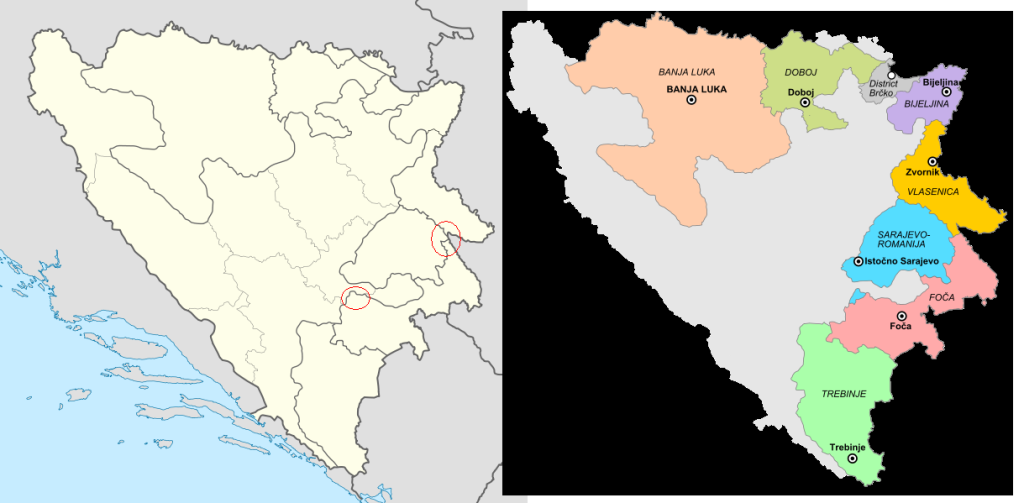
Regions in Republika Srpska
-
 The map that should been edited. As seen it lacks regions in Republika Srpska, while cantons in Federation of Bosnia and Herzegovina are maped. The regions are as important as the cantons.
 -
 Regions added.


Article(s): Many articles contain this picture
Request: Although the map is good, I would consider that adding borders for regions in Republika Srpska would be welcomed. I'm not profound with maping and I think no one should have something against it (England map has also borders for its regions). Here is a link for the regions (found in article Municipalities of Republika Srpska). Although Brčko District is maped in it, it is an entity of its own, not a part of Republika Srpska. But it is maped to keep a contiunity of the regions. AnelZukic (talk) 03:58, 26 September 2011 (UTC)
Graphist opinion(s):
I can't make heads or tails of your story. Do you want a map of the Srpska Regions in a color different from the rest of the region. Or do you want the border to be outlined with a different color or with a thicker line. You mention England. Can you perhaps give a map of England in which everything is drawn as you want it to be drawn in this map? Please be more clear. Wereldburger758 (talk) 06:49, 26 September 2011 (UTC)
- Sorry for not being clear enough. No, I don't want the regions in different colors, I wanted something like this, but just the lines same as the one used to seperate the cantons, that means not that thick, since the regions are part of Republika Srpska, and now they look like, how to say, more political important, what is not really what I want. Here is what I thought with England (link), but the situation in England isn't that complex as in Bosnia and Herzegovina, which has two two main political entities, FBiH which is divided in ten cantons and RS which is divided in seven regions. So to make it short, I would just like if you would make the recent, by you made, lines a bit less thick, that means as thick as the one used to seperate the cantons within Federation of Bosnia and Herzegovina. And their is a little part of Sarajevo-Romania region (it's seperated from the core region) that you have put in Foča region and the border of Vlasenica region isn't really correct (here, I circled the mistakes link). Sorry for the trouble and thank you. AnelZukic (talk) 02:57, 27 September 2011 (UTC)
- Okay, is this what you want? map
- Or this? map_1
- The second map is perfect, exactly what I wanted. Thank you! :) But just one more question. I would like to upload it as a .svg file, is it possible to convert it? I tried to use some online convertors but didn't had luck... AnelZukic (talk) 17:15, 27 September 2011 (UTC)
- Lol. No, I have made two svg-files and then made png-files of it. Didn't want to upload stuff I wasn't sure of. It should be fine now as it is. Look at my uploaded file in the gallery above. It is a svg-file.
- Sorry for the trouble, thank you a lot :D AnelZukic (talk) 23:55, 1 October 2011 (UTC)
- Lol. No, I have made two svg-files and then made png-files of it. Didn't want to upload stuff I wasn't sure of. It should be fine now as it is. Look at my uploaded file in the gallery above. It is a svg-file.
- The second map is perfect, exactly what I wanted. Thank you! :) But just one more question. I would like to upload it as a .svg file, is it possible to convert it? I tried to use some online convertors but didn't had luck... AnelZukic (talk) 17:15, 27 September 2011 (UTC)
- Or this? map_1
- Okay, is this what you want? map
![]() Request taken by Wereldburger758.. I think I understand what you want.
Request taken by Wereldburger758.. I think I understand what you want.
![]() Done
Done
-
 Map of central San Diego with a pushpin for Point Loma

.svg?lang=en)
Article: Point Loma, San Diego
Request: Problem with the location of the pushpin on the pushpin map at this article. Please see the discussion at Talk:Point Loma, San Diego#About that location map.... Point Loma is a peninsula geographically, and is a neighborhood of San Diego politically; the neighborhood is basically contiguous with the peninsula. The map at the top of the page is not a good representation, because it shows the entire Point Loma area with a pushpin located way down at the extreme southernmost tip of the peninsula. Several of us have agreed that the pushpin is misleading because it suggests that only the tip of the peninsula is Point Loma, when in fact the whole peninsula is. At the very least, Point Loma is everything south of a line connecting the river mouth with the bay; many would consider it to be everything south of the river, north of the bay, and east of I-5. That area is too big (on the scale shown) for any pushpin to be accurate, and we are leaning toward simply deleting the pushpin. None of us knows how to do that! Another approach would be to shift to a different map scale which would reduce Point Loma to a size appropriate for a pushpin. Any help or knowledgeable advice appreciated. --MelanieN (talk) 05:12, 4 October 2011 (UTC) MelanieN (talk) 05:30, 4 October 2011 (UTC)
- P.S. Sorry, I can't figure out the name of the map
Graphist opinion(s):
- The pushpin is the result of code and not the result of a drawing. You must go under the hood so to speak. This page gets you under the hood: [2] Wereldburger758 (talk) 07:02, 5 October 2011 (UTC)