
Wikipedia:Graphics Lab/Map workshop/Archive 01
This page is for listing articles that need maps.
When making a request, please leave a brief description of the type of map the article needs. Add a signature and timestamp (~~~~) at the end so that you can be contacted if there are any questions about the request.
For other map requests, see Category:Wikipedia requested maps.
For non-map image requests, see Wikipedia:Requested pictures.
For India-related map requests see Wikipedia:WikiProject Indian maps
Individual articles
- Seattle. Image:Seattle_map.png is a fine base, but the creator hasn't been seen on Wikipedia since late 2004 and never finished it. Could really use someone with local expertise to update and add many more points of interest or simply recreate, adding some major arterials and freeways in the process? In the meantime, Seattle lacks a good map, which is a shame. Thanks! --Lukobe 07:02, 18 April 2007 (UTC)
- March of Brandenburg (I am currently turning that redirect into an article by translating de:Mark Brandenburg) it would be nice if someonce could translate the following map from the German Wikipedia: de:Bild:MarkBrandenburg.png. If you contact me I'll tell you how to translate the geographic terms.--Carabinieri 19:16, 18 January 2007 (UTC)
 Is it ok if I make a similar map ? Because it will be too messy rubbing out the german text and typing in English. Or else you can ask the original uploader for the map background and it will then be easy to make the English version. Jackaranga 19:47, 7 October 2007 (UTC)
- List of Baltimore neighborhoods Passdoubt 21:18, 26 March 2006 (UTC)
- There are several hundred! But I can try to get the shapefile from Baltimore City Dept of Planning. In the meantime, this map provided by the aforementioned department should suffice. --Eplack (talk) 20:13, 18 December 2007 (UTC)
- That's copyrighted. Still excellent as a reference. Kmusser (talk) 21:14, 18 December 2007 (UTC)
- There are several hundred! But I can try to get the shapefile from Baltimore City Dept of Planning. In the meantime, this map provided by the aforementioned department should suffice. --Eplack (talk) 20:13, 18 December 2007 (UTC)
- New York Legislature- map of current Senate and Assembly districts with district numbers and if possible with partisan control
- Portes du Soleil
- Abitibi County, Quebec
- City map of Bath
- Bondi Beach
- Tiananmen Square's location in Beijing China. Additionally Cao Rulin's house in relation to Tiananmen Square and the May 4th Movement. Waarmstr 18:45, 26 January 2006 (UTC)
- A map of the world in 1837. - for what article? there is a public domain one here from 1840, but I don't know if that's what you're looking for.Kmusser 14:03, 14 September 2006 (UTC)
- Let me clarify. I'm doing a blank world map showing the borders at the start of Queen Victoria's reign. Her reign began in 1837. Something like this would be great.
- National Auto Trail
- Circumferential Highway (Nashua) Needs a map showing: Currently completed route and proposed routing(s). Information for the proposed routing can be found in the references section of said article. --Jayron32 05:37, 25 October 2006 (UTC)
- An accurate map on distribution of world religions needs to be created to replace the grossly inaccurate Image:Worldreligion.png. One source that could be used is [1]. deeptrivia (talk) 21:12, 19 May 2007 (UTC)
- Via Valeria - the article gives specific geographical information, which isn't really comprehensible without a historical map. --Wetman 19:35, 10 September 2007 (UTC)
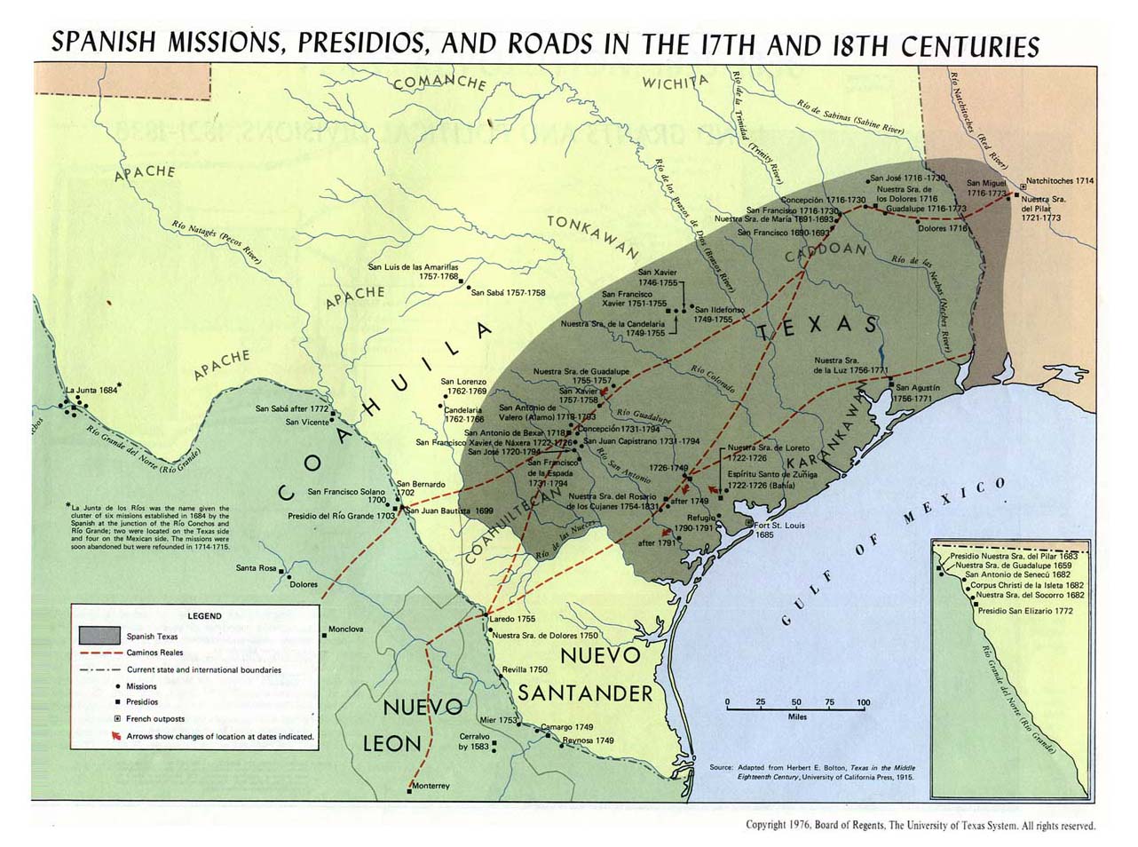
- Spanish Texas - I'd like to base a map on this map, showing the boundaries of Spanish Texas. Karanacs (talk) 17:03, 6 December 2007 (UTC)
- Tax haven
- Indiana Territory showing the changes in boundaries more clearly the transfer that occurred in 1803 and to a lesser degree that of 1816. Image:Indianaterr.PNG somewhat oversimplifies the eastern boundary transfer in 1803 -- in addition to the gore that was transferred from Ohio to Indiana, a relatively narrow strip north of Fort Recovery was transferred from Indiana to Ohio. older ≠ wiser 14:47, 3 October 2008 (UTC)
![[1]](https://www.neiu.edu/~ejhowens/104/religion.gif)
Improvement requests
Improvement requests can also be made to the Graphics Lab.
- List of Philadelphia neighborhoods could use more specific maps showing approximate neighborhood locations w/in sections. See Neighborhoods of Chicago for example. Passdoubt 21:18, 26 March 2006 (UTC)
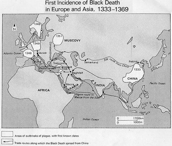
- Black Death, a map of the spread of the plague (using arrows or colors) would be great, and they seem to be common in all of the books I have read.--Dmcdevit 20:43, 22 Mar 2005 (UTC)
- I think Image:Bubonic plague map.PNG covers this nicely. ¦ Reisio 01:51, 17 October 2005 (UTC)
- That map is already included in the article. I believe the requestor was looking for a map similar to this one showing global spread. --NormanEinstein 13:29, 17 October 2005 (UTC)
- Muslim History: Image:Ayyubid.png could badly use some attention. Someone ambitious could do it for all of commons:Category:Maps_of_the_Caliphate. commons:Category:Maps of the history of the Middle East has some good examples.
- There is a map of exploration in the Antarctic here but it is in German. Any chance this could be recreated in English? Thanks Andeggs 12:39, 14 June 2007 (UTC)
Re-creation requests
Note: the following offline images are not available under the GFDL. It is requested that they be re-created and uploaded. These requests were moved from Wikipedia:Image recreation requests. – Quadell (talk) (sleuth) 20:14, Mar 8, 2005 (UTC)
- [2] - 14 maps of France during the Hundred Years' War. Neutralitytalk 23:01, Feb 19, 2005 (UTC)
- [3] - The Hundred Years War in 1328.
- [4] - The unification of France. Neutralitytalk 23:22, Feb 19, 2005 (UTC)
- [5] - The travels of Ferdinand and Isabella. Neutralitytalk 23:24, Feb 19, 2005 (UTC)
- [6] - The Italian Wars with battle sites. Neutralitytalk 23:24, Feb 19, 2005 (UTC)
- [7] - Religion in Europe, 1555. Neutralitytalk 23:26, Feb 19, 2005 (UTC)
- [8] - Expansion of Sweden. Neutralitytalk 23:26, Feb 19, 2005 (UTC)
- [9] - Expansion of Russia to the west in eastern Europe. Neutralitytalk 23:26, Feb 19, 2005 (UTC)
- [10] A worldmap, where the countries is sized by amount of people, not geographical size. moralist 12:49, 14 March 2008 (UTC)
![[3]](http://www.geocities.com/patricia_d_hernandez/TheHundredYearsWar.gif)
![[4]](http://wps.ablongman.com/wps/media/objects/262/268312/art/figures/KISH259.jpg)
![[5]](http://wps.ablongman.com/wps/media/objects/262/268312/art/figures/KISH262.jpg)
![[6]](http://wps.ablongman.com/wps/media/objects/262/268312/art/figures/KISH265.jpg)
![[7]](http://wps.ablongman.com/wps/media/objects/262/268312/art/figures/KISH_13_309.gif)
![[8]](http://wps.ablongman.com/wps/media/objects/262/268312/art/figures/KISH308.jpg)
![[9]](http://wps.ablongman.com/wps/media/objects/262/268312/art/figures/KISH_14_324.gif)
![[10]](http://fc01.deviantart.com/fs29/i/2008/072/a/c/worldmap_by_moralisten.jpg)
Batch requests
The following are lists of articles which could use maps created in a systematic fashion.
Countries
- I've checked through the list of countries to see that all country articles have 1.) a locator map that shows the position of the country in the world, appearing in the country's infobox at the top of the article, on the right, and 2.) some sort of general orientation map showing major cities, major landforms, boundaries with neighboring countries, etc. These may also show internal political divisions (e.g. provinces) major transportation features, such as roads, rail lines, canals, rivers, and airports, if scale allows. The maps in the CIA World Factbook (barely) satisfy the second requirement, and are public domain, so these could easily be deployed to fill in many gaps. Country maps may also be hidden on that country's subarticles, or elsewhere on the project. These articles are important because the Wikipedia:Version 1.0 Editorial Team is creating offline versions of the encyclopedia based on them. User:Blofeld of SPECTRE has recwently created many of the missing ones at User:Blofeld of SPECTRE/Missing locator maps.-- Beland 22:17, 9 December 2006 (UTC)
- Transnistria - Locator map shows position in Moldovia, due to disputed status.
- San Marino - Could use a map showing its relationship to Italian cities.
- Seychelles - Needs general map.
- Singapore - Needs general map, especially showing names of nearby countries.
- Spain - Needs general map.
- Turkey - Needs general map.
- United Kingdom - It would be nice to replace the CIA general map with a better one that showed the boundaries of the Home Nations.
- United States - General map does not show the names of major cities, nor names of neighboring countries. Also, the location of Hawaii in the world is not clear, and important territories like Puerto Rico are missing.
- Vatican City - Could use a map detailing its location in Rome and Italy.
- Wallis and Futuna - Needs general map.
Unrecognized countries
- It would be useful to check to see what entities on the list of unrecognized countries and related articles don't yet have maps. -- Beland 19:55, 9 December 2006 (UTC)
Country subdivision maps
The list of country subdivisions is missing maps (and indeed, missing articles) for many countries. -- Beland 19:55, 9 December 2006 (UTC)
United States Municipalities
Coordinated on User:Seth Ilys/Dot Project.
Cities
Most cities outside of the U.S. could use locator maps similar to those being made as part of the User:Seth Ilys/Dot Project. The following cities had been listed in individual articles above. For Japanese cities they just need to be copied from the Japanese wiki.
- Saudi Arabian major cities: Qatif; other smaller cities also need maps
- We could do with consistent maps in each of the 33 London Borough articles showing the extent of the borough, preferably with major roads included. I'm trying to answer questions like "which borough is Tottenham Court Road in?". It's not easy and perhaps not possible at the moment. Oh. Unless I use the categories at the foot of the article. Maps would still be lovely, though.--Tagishsimon (talk) 15:28, 19 March 2008 (UTC)
Historical regions of the United States
Canada
- Past Canadian electoral districts (including historical provincial, territorial and colonial-era) (Example: Coast Chilcotin) Skookum1 07:54, 23 November 2005 (UTC)
- WikiProject British Columbia is looking for many maps that are listed here. KenWalker | Talk 21:52, 28 January 2007 (UTC)
Seas, bays, and gulfs of the world
Europe
- Historic regions
- Medieval feudal states of Europe, more specifically: (Aquitaine, Bavaria, Brandenburg, Burgandy, Flanders, Friesland, Ile de France, Provence, Saxony, Toulouse, Connacht, Mide, Munster, etc.)
- Can you be more specific? For what dates do you want maps of these states? Or do you want maps, or sets of maps, showing how their borders changed? Maproom 16:02, 10 November 2007 (UTC)
- I think most of those have gone into Category:Former country articles requiring a map Kmusser 18:27, 10 November 2007 (UTC)
- Cities of Italy: e.g. Turin (needs a local map)
- Prigorodny District, Republic of North Ossetia-Alania, and other districts --Sabs1285 19:58, 31 January 2006 (UTC)
- Prigorodny is done but the other districts still need maps. Kmusser 16:49, 11 December 2006 (UTC)
- general historic maps of europe (either old maps or user-created) to fill the many gaps on commons:Template:Maps of the history of Europe
Wars
- General maps
- Resources and industrial capacities in WWI and WWII
- It would be great if someone took on the task to create a map of where different FARC fronts are active. The fronts and their locations where they are active can be found under FARC-EP Chain of Command by looking at each individual bloc.
(Wikipedia_talk:WikiProject_Military_history/Requests#world_war_2_building_capacities)
- Wars where territory changed hands, e.g.:
- Battle of Muret
- Indian Wars (currently only external images)
- Merge: Image:Huns empire.png and Image:Invasions of the Roman Empire 1.png to replace of Image:450 roman-hunnic-empire 1764x1116.jpg
- Replace Image:Rome carthage 218.jpg with a new map showing the independence of Syphax and Hannibals conquest north of the Ebro in Second Punic War
- Map for the course of the Second Punic War take this as an example but show also Roman/Carthaginian allies in Northern Italy, and along the coast + loss of Carthaginian possessions north of the Ebro
- Battles of tactical significance - tactical maps would be great.
- Battle of Ichi-no-Tani
- Battle of Dan-no-ura
- Battles of Kawanakajima (fourth battle)
- Battle of Nagashino
- Roman-Spartan War (showing the movment of troops)
- And Treaties and Peaces:
Rivers
Category:River articles needing maps.
Railroads
Wikipedia:WikiProject Trains/Maps task force.
Reservations
Almost none of the articles on Native American reservation have maps. See Category:American Indian reservations.
Explorers
None of the Age of Discovery explorers have maps! Not even Christopher Columbus! It would be incredibly useful for someone to to make maps of where they went, and perhaps maps of the world with all explorers from a certain time period. However, this is truly a batch request because they all need to be consistant. Don't do only one.
Category: Explorers should give you a place to start. If anyone has a concern, I'm HereToHelp (talk) 13:20, 5 November 2005 (UTC)
History of India
These articles would be using maps based on the same template, hence included in batch requests. This is a part of History of India wikiproject. Help would be highly appreciated.
- Forward requests to Wikipedia:WikiProject Indian maps =Nichalp «Talk»= 06:38, 22 February 2007 (UTC)
list:
- Routes, Wars, etc.
- Kamboja-Dvaravati Route
- Anglo-Maratha wars, based on [11]
- Anglo-Sikh wars, based on [12]
- Anglo-French wars (India), based on [13]
- Osmanistan, based on [14]
![[11]](http://www.history.upenn.edu/coursepages/hist086/material/schmidt34a.jpg)
![[12]](http://www.history.upenn.edu/coursepages/hist086/material/schmidt37a.jpg)
![[13]](http://www.history.upenn.edu/coursepages/hist086/material/schmidt30a.jpg)
![[14]](http://www.shelleys.demon.co.uk/dinia.jpg)
Districts of India
- Shajapur District- map of the district. I'd greatly appreciate it. Raisethirty 21:11, 15 August 2006 (UTC)
- I moved this request to the batch section because all the other Districts need maps as well. Basemaps to make these already exist [on commons]. Kmusser 03:27, 12 January 2007 (UTC)
- Forward requests to Wikipedia:WikiProject Indian maps =Nichalp «Talk»= 06:38, 22 February 2007 (UTC)
Sovereign states by year
A World map for each year for the series of articles Sovereign states by year, indicating all the sovereign states and highlighting the changes of each year (a big project, yes). Sobirà 11:33, 15 October 2006 (UTC)
- Sobirà, world maps are very poor vehicles to show countries: there just isn't enough "bandwidth" to accommodate the necessary data. The problem starts with the fact that the earth's surface is 3/5ths water, so only 40% of the map can be used. Add in problems with projection, and you end up being able to show only the very largest countries, and being relatively unable to label even these adequately. Sorry for the negative opinion, MapMaster 03:00, 18 October 2006 (UTC)
- It's an interesting answer, but I've seen lots of political maps of all the globe. Lots of them used this 60% of the sea for letters and magnifications of interesting lands. In the project State leaders by year, leaders are separated by regions. I suppose that in this case could be feasible do the same. I suppose that with this option would be easier recycle maps in different years. Sobirà 15:44, 20 October 2006 (UTC)
- I'm working on kind of a similar thing - I'm making maps of each continent by year (or rather, by major change). However, since I'm starting with North America, it's simple so far. ;) --Golbez 14:47, 23 January 2007 (UTC)
- You are correct in that the seas etc (unusable space) could be used for names, magnifications, etc. However, to show you the problems involved, take a look at this map of Europe in 800 AD. This map is so big it can't even fit on my screen, and yet some of the names approach unreadable. And this is only one continent, perhaps 8% to 10% of the world's surface. MapMaster 20:13, 20 October 2006 (UTC)
- I was thinking in something symilar to the map of List of sovereign states in 820 where you can have a general idea of the situation but if you want to see more details and read the names you have to click on the map and see the high resolution version. I don't see it impossible, or bad. Sobirà 16:36, 21 October 2006 (UTC)
- It's an interesting answer, but I've seen lots of political maps of all the globe. Lots of them used this 60% of the sea for letters and magnifications of interesting lands. In the project State leaders by year, leaders are separated by regions. I suppose that in this case could be feasible do the same. I suppose that with this option would be easier recycle maps in different years. Sobirà 15:44, 20 October 2006 (UTC)
- Similar to the above request, blank historical maps are very useful, some are at commons:Category:Blank maps of the world for historical use, but many more could be created.
Calvinism
Calvinism in Europe. P.S. Can I make a map by myself? What's the system? Thanks...Amiens984 (talk) 22:00, 7 October 2008 (UTC)
- Sure you can. No system. --Golbez (talk) 22:35, 7 October 2008 (UTC)