
Wikipedia:Graphics Lab/Map workshop/Archive/May 2023
| This is an archive of past discussions on Wikipedia:Graphics Lab, for the period 2023. Do not edit the contents of this page. If you wish to start a new discussion or revive an old one, please do so on the current main page. |
 | Archives of 2023: January, February, March, April, May, June, July, August, September, October, November, December |
Quick update
{{stale}}
-
 No promo homo and school bullying laws
 -
 Updated map, now only showing laws related to school bullying.
 -
 New map showing laws related to LGBT inclusive instruction in the classroom.


This Map needs to be updated with Florida and Alabama in the Red for State law that forbids instruction on LGBT issues within public schools. La lopi (talk) 15:44, 21 May 2023 (UTC)
 Request taken by Dragon401k (talk) 20:33, 21 May 2023 (UTC). I'm noticing a bunch of different issues with this map. I'll start with the smaller issues and move into the more fundamental.
- First of all, it needs to be remade into a text-editable version-- one of the upload logs says "please don't use Inkscape to edit these files", but all the file versions, including the original, are Inkscape created. The basemap listed in the description also looks to be incorrect, as it's state-level, not county. File:Usa counties large.svg is the best basemap to use, as it's text-editable and county-level.
- Secondly, it looks like File:School bullying laws in the United States.svg is identical in scope to this map, but sometimes edits aren't made to both versions. Seems like one of these maps should be superseded, as they both (aim to) show the same information.
- Thirdly, there are some issues with the concept behind the map. This map aims to chart two different types of laws:
- Laws prohibiting discrimination/bullying against LGBT students
- Laws prohibiting LGBT-positive classroom instruction (also called "No promo homo" and "Don't say gay" laws).
- I can understand why it would be helpful to view these two types of laws together, as they're closely related. But it leaves out another closely related type of law, which is laws that mandate LGBT-positive classroom instruction. [1] Of course, adding that category would make the map even more cluttered.
- I propose splitting this into two maps: one that shows laws prohibiting LGBT discrimination/bullying in schools, and another that shows laws related to LGBT-positive curriculum (both prohibiting and mandating it). I think that could be accomplished by having File:School bullying laws in the United States.svg be the first map in question, and then creating a new file for the second map. File:No promo homo and school bullying laws in the United States.svg would be superseded by File:School bullying laws in the United States.svg.
- Open to input from you, @La lopi, as well as others. I'll get started making the versions I proposed using the text-editable basemap, which would make it much easier to combine/dis-aggregate the maps based on what people have to say. Dragon401k (talk) 20:33, 21 May 2023 (UTC)
- @Dragon401k Hi to tell you the truth I was actually thinking the same on the many issues you raised. Thank you for talking about it.La lopi (talk) 23:04, 21 May 2023 (UTC)
 Done @La lopi I've updated File:School bullying laws in the United States.svg to remove the curricular laws (shown in gallery). I tried to update the basemap to a text-editable version, but there was a rendering issue. There doesn't seem to be a good county-level basemap that includes territories and is text-editable, so I just left the basemap alone for now and updated it with Inkscape. I also created File:LGBT Curricular Laws in the United States.svg (shown in gallery) and added superseded templates directing users to the new maps on File:No promo homo and school bullying laws in the United States.svg. I may keep working on updating the basemap for File:LGBT Curricular Laws in the United States.svg, but it's satisfactory as is. Dragon401k (talk) 23:18, 26 May 2023 (UTC)
- @Dragon401k Thanks for making the Map.La lopi (talk) 11:00, 27 May 2023 (UTC)
- @Dragon401k Hi, i posted this map https://en.wikipedia.org/wiki/File:LGBT_Curricular_Laws_in_the_United_States.svg on a couple pages and some guy removed it. By saying removed inaccurate map, no source provided on how Montana, Arizona, etc." prohibit LGBT inclusive instruction in the classroom". i will check the issue but can you also. Thanks. La lopi (talk) 05:28, 28 May 2023 (UTC)
Aguascalientes Department map
{{resolved}}
-
 The first example (map of the Arizona Department).
 -
 The second example (map of the California Department).
 -
 The source map – Arizona and California maps were derived from it, as should be the future Aguascalientes map.
 -
 The map that indicates the location of the Aguascalientes Department (it is numbered as "21").


.svg?lang=en)
- Article(s)
- Aguascalientes Department
- Request
- Please create a separate map of the Aguascalientes Department, modeled on the existing maps of the Arizona Department and the California Department. — Sundostund mppria (talk / contribs) 02:21, 12 June 2023 (UTC)
- Discussion
- Hi @Sundostund, done with this file. I've updated it to use the standard locator map conventions and colours, but am happy to amend it to the above style as needed. – Isochrone (T) 15:09, 16 June 2023 (UTC)
- Hi @Isochrone! Thank you so much for your work! It does look fine, but I would prefer if you change it to the above style – this map should be the same as the Arizona and California maps, just for the sake of consistency. — Sundostund mppria (talk / contribs) 15:14, 16 June 2023 (UTC)
- @Sundostund Done – Isochrone (T) 15:18, 16 June 2023 (UTC)
- @Sundostund
- Hi @Isochrone! Thank you so much for your work! It does look fine, but I would prefer if you change it to the above style – this map should be the same as the Arizona and California maps, just for the sake of consistency. — Sundostund mppria (talk / contribs) 15:14, 16 June 2023 (UTC)
Italians in Venezuela
-
 Shows distribution of Italian-speakers in Venezuela

- Article(s)
- Italian language in Venezuela
- Request
- I came across this map that uses two shades of yellow, one shade for background, and another foreground shade to show where Italian-speakers are located. The background and foreground colors are too similar, please change one of them to a non-yellow color, thanks. Anythingyouwant (talk) 17:54, 11 May 2023 (UTC)
- Discussion
- This image seems WP:OR, and is made redundant by file:ItaliansInVenezuela.png and file:Porcentaje Italianos en Venezuela (2011).png. The image description and categories make out that it represents ethnicity rather than language, but its use on Italian Venezuelans and Italian language in Venezuela contradicts this. Overall, it's a bad image that might deserve deletion. small jars
tc17:57, 31 May 2023 (UTC)- Thanks for the info. Can you please go ahead and submit a deletion request? Anythingyouwant (talk) 18:09, 31 May 2023 (UTC)
- Hi @Anythingyouwant, is this resolved? If so it would be great if you could tag it with {{resolved}}, thanks. – Isochrone (T) 18:00, 17 June 2023 (UTC)
- Thanks for the info. Can you please go ahead and submit a deletion request? Anythingyouwant (talk) 18:09, 31 May 2023 (UTC)
{{resolved}}
Flag map of Rhodesia (1964–1968)
{{resolved}}
-
 Flag map of Rhodesia (1964–1968).
 -
 Flag of Rhodesia (1964–1968), which the map on the left is supposed to be based on.
 -
Flag map of Rhodesia, 1968–1979 (for comparison).
-
 Flag map of Zimbabwe (also for comparison).
 -
New file
.svg?lang=en)
.svg?lang=en)

- Article(s)
- Any articles where flag maps are relevant.
- Request
- Alright, could someone please modify the above file depicting the "Flag map of Rhodesia (1964–1968)", so that the flag properly "fills up" the whole map, in the same kind of way as the other two Rhodesian/Zimbabwean flag maps shown above? I'd imagine the altered file would look something like this, albeit obviously with a sky blue background instead of a dark blue one. Thanks. Snow Lion Fenian (talk) 13:56, 26 May 2023 (UTC)
- Discussion
- Hi @Snow Lion Fenian, something like File:Flag map of Rhodesia (1964–1968, zoomed).svg? – Isochrone (T) 20:47, 7 June 2023 (UTC)
- @Isochrone: Thanks for taking this on! Although is there any chance the Union Jack and shield could be repositioned and resized so that they match the positions and sizes shown in this particular link? Snow Lion Fenian (talk) 22:25, 7 June 2023 (UTC)
- @Snow Lion Fenian is the current rendition better? – Isochrone (T) 19:12, 8 June 2023 (UTC)
- @Isochrone: That's great! Just one more thing... there appears to be a small piece missing out of the outline of Rhodesia on the current version of the map (visible to the upper-right of the Union Jack). Any chance that could be remedied? Sorry about this, and thanks again. Snow Lion Fenian (talk) 22:33, 8 June 2023 (UTC)
- This seems to be because the top right of the Union Jack is white; I can move up if you want? – Isochrone (T) 15:52, 9 June 2023 (UTC)
- @Isochrone: Well, I was actually referring to the fact that there's a very small triangular-ish chunk missing from the northern border area of Rhodesia, possibly due to a glitch. If you copy and paste the image onto a black background, you'll see what I mean. Snow Lion Fenian (talk) 23:46, 9 June 2023 (UTC)
- @Snow Lion Fenian apologies for the delay, Done – Isochrone (T) 14:55, 16 June 2023 (UTC)
- @Isochrone: No problem, and thank you for fixing that glitch! And, before I close this request, I have one more (rather trivial) adjustment to ask for; Could you perhaps enlarge the map so that it's the same size as in the previous two versions of the file? Snow Lion Fenian (talk) 23:02, 16 June 2023 (UTC)
- Weird,
 Fixed @Snow Lion Fenian – Isochrone (T) 17:57, 17 June 2023 (UTC)
- @Isochrone: That's perfect, and thanks for bearing with me throughout this rather long request. Very much appreciated. Snow Lion Fenian (talk) 20:32, 17 June 2023 (UTC)
- Weird,
- @Isochrone: No problem, and thank you for fixing that glitch! And, before I close this request, I have one more (rather trivial) adjustment to ask for; Could you perhaps enlarge the map so that it's the same size as in the previous two versions of the file? Snow Lion Fenian (talk) 23:02, 16 June 2023 (UTC)
- @Snow Lion Fenian apologies for the delay,
- @Isochrone: Well, I was actually referring to the fact that there's a very small triangular-ish chunk missing from the northern border area of Rhodesia, possibly due to a glitch. If you copy and paste the image onto a black background, you'll see what I mean. Snow Lion Fenian (talk) 23:46, 9 June 2023 (UTC)
- This seems to be because the top right of the Union Jack is white; I can move up if you want? – Isochrone (T) 15:52, 9 June 2023 (UTC)
- @Isochrone: That's great! Just one more thing... there appears to be a small piece missing out of the outline of Rhodesia on the current version of the map (visible to the upper-right of the Union Jack). Any chance that could be remedied? Sorry about this, and thanks again. Snow Lion Fenian (talk) 22:33, 8 June 2023 (UTC)
- @Snow Lion Fenian is the current rendition better? – Isochrone (T) 19:12, 8 June 2023 (UTC)
- @Isochrone: Thanks for taking this on! Although is there any chance the Union Jack and shield could be repositioned and resized so that they match the positions and sizes shown in this particular link? Snow Lion Fenian (talk) 22:25, 7 June 2023 (UTC)
Holocaust deaths map
- Content
| Country | 1939 Jewish population | Holocaust deaths | percentage |
|---|---|---|---|
| Belgium | 90,000 | 24,387 | 40[3] |
| Bohemia and Moravia |
118,310 | 80,000[4] | 80[5] |
| Estonia | 4,500 | 963 or 1,000[6] | 21 |
| France | 300,000–330,000 | 74,000 | 22 |
| Germany (including Austria) | 420,000 | 230,000 | 54 |
| Greece | 77,000 | 67,000 | 87[7] |
| Hungary | 637,000[8] | 415,000[9] | 65 |
| Italy | 58,412 | 7,858 | 13 |
| Latvia | 93,479 | 70,000 | 75 |
| Lithuania | 153,000 | 130,000 | 85 |
| Luxembourg | 3,800 | 1,200 | 32 |
| Netherlands | 140,245 | 102,000 | 73 |
| Norway | 1,800 | 758 | 42 |
| Poland | 3,300,000 | 3,000,000 | 90 |
| Romania (1930) | 756,000 | 250,000 | 30 |
| Slovakia | 89,000 | 69,000 | 77[10] |
| Soviet Union | 3,028,538 | 1,340,000 | 44 |
| Yugoslavia | 82,242 | 67,228 | 82 |
- Article(s)
- The Holocaust#Death toll (replacing the table)
- Holocaust victims
- Evidence and documentation for the Holocaust (replacing the existing map)
- Request
- I'd like to make a map based on Europe's 1939 borders (possibly with this map as a base) that portrays the absolute and relative Jewish population losses during the Holocaust. It would be similar to this one but include a bar graph for the absolute magnitude of losses. I would also like the map to portray migration of 300,000 Jews out of Europe from 1933–1941[11] with an arrow pointing west towards the Atlantic Ocean and another 1.8 million[12] with an arrow pointing east to Siberia from 1939–1941. The absolute and percentage deaths are listed in the table. Countries where the Holocaust did not occur—Switzerland, Turkey, Sweden, Iceland, the UK, Spain, Portugal, Ireland, Libya,[13] Morocco,[13] and Tunisia[13]—should be in a different color (maybe gray)? Denmark,[1] Finland,[14] Albania,[15] Bulgaria,[16] (which had very low Holocaust-related deaths of the Jewish population within their prewar borders) should be entered as zero deaths and <2 percent losses. I expect the bar for Poland will have to be really long in order so that lower counts are still visible, but it's ok if Norway and Estonia don't show up.
This project is sadly beyond my mapmaking capabilities so I would appreciate any help. -- (t · c) buidhe 04:01, 9 May 2023 (UTC)
References
- ^ a b https://encyclopedia.ushmm.org/content/en/article/jewish-losses-during-the-holocaust-by-country?parent=en%2F11652 unless otherwise stated
- ^ Numbers don't add up because of different prewar estimates and sources used. Nevertheless, I would like to use the percentages and absolute deaths in the table as written.
- ^ Gerlach 2016, p. 439.
- ^ Gruner, Wolf (2019). The Holocaust in Bohemia and Moravia: Czech Initiatives, German Policies, Jewish Responses. Berghahn Books. p. 380. ISBN 978-1-78920-285-4.
- ^ Láníček, Jan (2013). Czechs, Slovaks and the Jews, 1938-48: Beyond Idealisation and Condemnation. Springer. p. 1. ISBN 978-1-137-31747-6.
- ^ Weiss-Wendt, Anton (2009). Murder Without Hatred: Estonians and the Holocaust. Syracuse University Press. p. 131. ISBN 978-0-8156-3228-3.
- ^ Antoniou, Giorgos; Moses, A. Dirk (2018). "Introduction". The Holocaust in Greece. Cambridge University Press. pp. 1–12. ISBN 978-1-108-47467-2.
- ^ USHMM figure of 490,621 for pre-1937 borders, plus 146,000 formerly Czechoslovak Jews (Schmidt-Hartmann p. 375); not including the Second Vienna Award
- ^ USHMM figure of 297,621 for pre-1937 borders, plus 114,000 - 120,000 formerly Czechoslovak Jews (Schmidt-Hartmann, p. 377)
- ^ Cichopek-Gajraj, Anna (2014). Beyond Violence: Jewish Survivors in Poland and Slovakia, 1944–48. Cambridge: Cambridge University Press. p. 19. ISBN 978-1-107-03666-6.
- ^ Gerlach 2016, p. 100.
- ^ of these 1.8 million, 200,000 from Poland (Edele et al. p. 15) and 1.6 million from the Soviet Union (Gerlach, Christian (2016). The Extermination of the European Jews. Cambridge University Press. pp. 72–73. ISBN 978-0-521-70689-6.)
- ^ a b c Gerlach 2016, p. 115.
- ^ https://link.springer.com/chapter/10.1057/9781137302656_9
- ^ Gerlach 2016, p. 388.
- ^ https://www.tandfonline.com/doi/abs/10.1080/23256249.2017.1346743?journalCode=rdap20
- Discussion
- This could be a good use case for {{Graph:Map}}, which keeps the underlying data in wikitext and therefore makes it much easier to keep updated. Unfortunately, it relies on the graph extension, which is temporarily disabled. It also wouldn't accommodate the bar charts or the outward arrows, but I'd argue those aren't a great data visualisation choice anyway. The relative/absolute death tolls would be better presented as facets (i.e. two maps, or some sort of interactive toggle). – Joe (talk) 07:06, 9 May 2023 (UTC)
- For just displaying the death rate, I could make that map myself fairly easily—it's the other parts I'm not able to do. I can see that too much information on a map could be confusing, but I will see what anyone else has to say. (t · c) buidhe 16:56, 9 May 2023 (UTC)
Vostok 1 orbit

-
 currently used image
 -


- Article(s)
- Vostok 1, + spaceflight history articles
- Request
- Image of Vostok 1 orbit is of very low quality, need something better. Only two images are in Commons, another one is not in English and doesn't look really accurate. Thanks! Artem.G (talk) 17:36, 11 May 2023 (UTC)
- Discussion
Orca range map needs updating
-
 Current range map

- Article(s)
- Orca
- Request
- Range needs to be adjusted per the IUCN range information. Particularly, the North Sea and the Antarctic ranges should be expanded. Updating the given image is ok, as is making a new image. Thanks! - UtherSRG (talk) 14:11, 12 May 2023 (UTC)
- Discussion
Orca range map needs updating
-
Current range map
- Article(s)
- Orca
- Request
- Range needs to be adjusted per the IUCN range information. Particularly, the North Sea and the Antarctic ranges should be expanded. Updating the given image is ok, as is making a new image. Thanks! - UtherSRG (talk) 14:11, 12 May 2023 (UTC)
- Discussion
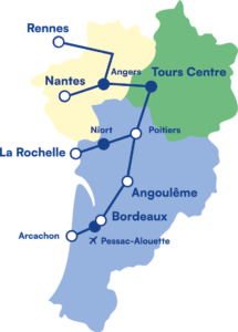
Le Train Network Map
{{resolved}}

.png?lang=en)
.svg)
.svg)
- Article(s)
- Le Train
- Request
- Hi all, I've been working on expanding the wiki article for Le Train, a private rail company in France, and would appreciate it if someone could make a map based on this low-resolution map they provide on their official website that I can include in the article. Thanks! -- Jh15s (talk) 13:25, 11 June 2023 (UTC)
- Discussion
- Request taken by M.Bitton (talk) 23:44, 18 June 2023 (UTC).
- @Jh15s: is the Angers to Rennes line correct (i.e., not straight) or has it been altered for readability purposes? If it is correct, do you know the location of that top corner? M.Bitton (talk) 23:33, 19 June 2023 (UTC)
- @M.Bitton: Thanks for taking up my request! I've had a look on OpenRailwayMap and OpenStreetMap and yes, the Angers to Rennes line does have a turn/corner where it turns left to head to Rennes. The nearest landmark seems to be a forest called the "Bois de Sirion" and the nearest towns are "Auvers-le-Hamon" and "Asnieres-sur-Vegre", though both are quite some distance away from the line itself. Here's a link to the location of the corner in question on OSM: https://www.openstreetmap.org/#map=14/47.9045/-0.3070 Jh15s (talk) 09:24, 20 June 2023 (UTC)
- @Jh15s: thanks, that's all I needed to know. M.Bitton (talk) 09:26, 20 June 2023 (UTC)
- @Jh15s: since you're familiar with the subject, would it possible for you to suggest a name for the map and provide what's needed for Commons (description, categories, structured data, etc.)? M.Bitton (talk) 09:36, 20 June 2023 (UTC)
- @M.Bitton: Sure - I'm not too sure about the Structured Data part so let me know if anything needs to be changed there:
- Name: Le Train Network Map
- Description: The proposed network map of upcoming French open-access high-speed rail operator Le Train.
- Structured Data: https://www.wikidata.org/wiki/Q116345636 https://www.wikidata.org/wiki/Q7096309 https://www.wikidata.org/wiki/Q211382 https://www.wikidata.org/wiki/Q4006 https://www.wikidata.org/wiki/Q84615405
- Categories: Rail transport maps of France, High-speed rail, High-speed rail in France Jh15s (talk) 10:04, 20 June 2023 (UTC)
- Thanks. M.Bitton (talk) 14:42, 20 June 2023 (UTC)
- Done @Jh15s: please have a look at the map and let me know if I missed anything or if something needs adjusting. I used this source to make it more precise, but you prefer straight lines (similar to the low resolution map), that can easily be done. M.Bitton (talk) 11:58, 21 June 2023 (UTC)
- @M.Bitton: Apologies for the late reply - I've had a look and the map looks great, thank you so much for doing this! I think geographical accuracy is probably better for Wikipedia rather than the more inaccurate straight lines the low resolution map uses so I think it's better we keep it as is. I've added the map into the infobox on the Le Train wiki article. Jh15s (talk) 11:07, 23 June 2023 (UTC)
- @M.Bitton: Thanks for taking up my request! I've had a look on OpenRailwayMap and OpenStreetMap and yes, the Angers to Rennes line does have a turn/corner where it turns left to head to Rennes. The nearest landmark seems to be a forest called the "Bois de Sirion" and the nearest towns are "Auvers-le-Hamon" and "Asnieres-sur-Vegre", though both are quite some distance away from the line itself. Here's a link to the location of the corner in question on OSM: https://www.openstreetmap.org/#map=14/47.9045/-0.3070 Jh15s (talk) 09:24, 20 June 2023 (UTC)