
Wikipedia:Graphics Lab/Map workshop/Archive/Jan 2023
| This is an archive of past discussions on Wikipedia:Graphics Lab, for the period 2023. Do not edit the contents of this page. If you wish to start a new discussion or revive an old one, please do so on the current main page. |
 | Archives of 2023: January, February, March, April, May, June, July, August, September, October, November, December |
E-Verify US Map
- Article(s)
- E-Verify
- Illegal immigration to the United States
- Request
- Hi i am just wondering can sombody make a USA Map, of US states On E-Verify.
As of January 1, 2023 the following states require E-Verify for some or all employers:
- Alabama,
- Arizona,
- Colorado,
- Florida,
- Georgia,
- Idaho,
- Indiana,
- Louisiana,
- Michigan,
- Minnesota,
- Mississippi,
- Missouri,
- Nebraska,
- North Carolina,
- Oklahoma,
- Pennsylvania,
- South Carolina,
- Tennessee,
- Texas,
- Utah,
- Virginia
- West Virginia.
Here are the sources.[1] Thanks.La lopi (talk) 02:01, 2 February 2023 (UTC)
- Discussion
Hi, I can take this but the source you gave is not clear at all about the states that require E-Verify on 1 January 2023. The information is until 2021 and I have not found any reference to the states in question.
![]() Request taken by Ikonact (talk) 15:44, 8 February 2023 (UTC).
Hi, i hope this helps i found this on the website of the National Conference of State Legislatures, it has its own map and information on the states (It should be noted it says these numbers are from 2015, So the Map could be called as E verify states as of 20150. hope this helps you. Thanks.[1] La lopi (talk) 01:48, 9 February 2023 (UTC)
Request taken by Ikonact (talk) 15:44, 8 February 2023 (UTC).
Hi, i hope this helps i found this on the website of the National Conference of State Legislatures, it has its own map and information on the states (It should be noted it says these numbers are from 2015, So the Map could be called as E verify states as of 20150. hope this helps you. Thanks.[1] La lopi (talk) 01:48, 9 February 2023 (UTC)
- @La lopi:Draft here. Could you please check and let me know. If you find a more recent source I will be glad to update. Thanks --Ikonact (talk) 22:30, 11 February 2023 (UTC)
- @Ikonact: Hi the map looks good, i had a check of the source and it looks good, i will keep a look out for updates for this map. but is it right with you, for the meantime i can put this map on the pages, that i planed to. thanks again, have a great weekend.La lopi (talk) 10:51, 12 February 2023 (UTC)
- @La lopi: I found this source from December 2022. I am not knowledgeable on the subject and I prefer to limit my intervention to generating maps with a source that is given by more experienced people. If you find this source reliable I can update the map based on it. I can put the five categories that are identified, namely:
- States that require all or most employers to use E-Verify: Alabama, Arizona, Georgia, Mississippi, North Carolina, South Carolina, Tennessee, and Utah.
- Public employers and/or contractors with the state: Florida, Indiana, Missouri, Nebraska, Oklahoma, Pennsylvania, and Texas.
- Public employers only: Idaho and Virginia.
- States with local/municipality E-Verify requirements: Colorado (Denver), Florida (Hernando County, Bonita Springs), Michigan (Ingham County, Macomb County, Oakland County), Missouri (O’Fallon), Nebraska (Fremont), and Washington (Hoquiam, Pierce County, Woodland).
- State contractors only: Colorado, Louisiana, and Minnesota.
- The categories are different. You can suggest grouping them. May be the fourth category can be omitted as it goes on lower level and some states are in other categories. Up to you! Thanks––Ikonact (talk) 15:52, 12 February 2023 (UTC)
- @La lopi: I found this source from December 2022. I am not knowledgeable on the subject and I prefer to limit my intervention to generating maps with a source that is given by more experienced people. If you find this source reliable I can update the map based on it. I can put the five categories that are identified, namely:
- @Ikonact: I checked that source, and i don't know about that group/website or feel comfortable using that source. I feel much more comfortable with the first map, and first source you done.La lopi (talk) 22:28, 12 February 2023 (UTC)
- OK, thanks @La lopi: If you need some further update please let me know. At this stage I consider it
 Done Ikonact (talk) 07:47, 13 February 2023 (UTC)
- OK, thanks @La lopi: If you need some further update please let me know. At this stage I consider it
{{resolved}}
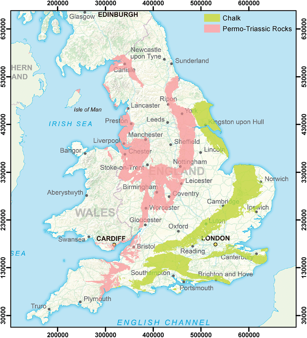
Topographical map of southern England
- Article(s)
- Downland, and may also be useful on multiple articles we have on specific downs.
- Request
- I want to create a map of the downland in the UK. For this I need a topographical map of southern England. I can add the annotation of hill range names myself. The map needs to go at least as far north as Cambridge and at least as far West as Exeter. To the south and the east it needs to go all the way to the sea. Thanks, SpinningSpark 15:39, 30 December 2022 (UTC)
- Discussion
Note that File:Blank topographic map of the British Isles.svg already exists. SpinningSpark 15:39, 30 December 2022 (UTC)
Extended content
|
|---|
.png?lang=en)
@Spinningspark: I do understand you have lost a map which you valued, I'm sorry for that.
|
Uploaded Downland in southern England
![]() Done
{{resolved}}
Done
{{resolved}}
Request
-
 Sub-Saharan Africa without the Sahel region
 -
 The Sahel region


- Article(s)
- Sub-Saharan Africa
- Request
- Add the Sahel region to sub-Saharan Africa in the map of sub-Saharan Africa because the Sahel region is a part of sub-Saharan Africa. The definition of sub-Saharan Africa is the area and regions of the continent of Africa that lie south of the Sahara, and the Sahel region is a region of the continent of Africa that lies south of the Sahara. -- Treetoes023 (talk) 01:46, 28 February 2023 (UTC)
- Discussion
@Treetoes023: No, it's not that simple. 1) There is no clear definition for any of them, let alone "sub-Sahara". 2) The source that use the definition that you mentioned tend to include the Sahel in the Sahara (this is the case for Britannica, the source that you wanted use when you made the first request). 3) If you want to show the countries that are often considered as part of Sub-Saharan Africa, then that's another subject. M.Bitton (talk) 12:53, 28 February 2023 (UTC)
- @M.Bitton: Yes, it's that simple.
- The Sahel has a clear definition, it is the region directly south of the Sahara that seperates the Sahara from the Sudanian savanna making it by defintion sub-Saharan.
- Britannica actually does acknowledge that the Sahel is not a part of the Sahara in both the Sahara's and Sahel's respective articles, along with many other sources such as these 123 (page 23) and more that I can provide if you want me to.
- The source I gave you when I first made my request was a mistake, I pulled the first image of google that clearly showed boundaries of the Sahara without really inspecting it which is entirely my fault. The source I gave you depicts the Sahara-Sahel which is lumps the Sahara and Sahel together due to political similarities and not geography which is what my request aims to depict.
- I'm sorry if my response comes off as rude, it is not my intention but I can see that it definitely sounds like someone who doesn't like you wrote it which is not the case I just don't have the time to change the wording to make it sound less aggressive because I have to study for SATs lol. Treetoes023 (talk) 20:23, 28 February 2023 (UTC)
- @Treetoes023: I disagree with your WP:OR based conclusion. My offer of creating a map that shows the countries that are usually considered by RS as part of Sub-Saharan Africa still stands (shown in the PDF that you cited). M.Bitton (talk) 20:29, 28 February 2023 (UTC)
- @M.Bitton: I do no think my conclusion is WP:OR. Some of the sources I provided directly support my claim, for example "The Sahel region of sub-Saharan Africa..." (page 23). That would make it not original research. Treetoes023 (talk) 03:08, 1 March 2023 (UTC)
- @Treetoes023: the map that you're proposing is pure WP:OR. The only sources that matter when it comes to creating maps are RS maps and not our interpretation of a text (unless it's unambiguous, such as lists of countries, etc). While the Sahara and the Sahel are physical regions, sub Saharan Africa is a political region that is rarely portrayed as a physical one (it took me ages to find a source for the physical region that you originally requested). In hindsight, and given the intended purpose of the map, that was a bad idea. I have now adjusted the maps so that they comply with RS and the common definitions. Sudan was added in light green (in line with the other map that is on the article). M.Bitton (talk) 18:46, 1 March 2023 (UTC)
- @M.Bitton: I agree with your decision, I am sorry for my stubbornness. Although, I still think a geographic map of sub-Saharan Africa is not without merit, not as the main picture on the article of course. Could you leave all of the maps as they originally were including that the Sahel was not included in sub-Saharan Africa and make separate maps based on the political definitions and we use the political based maps in the article. I think that the geography maps could be useful in the future even if they aren't useful right now. Treetoes023 (talk) 20:02, 1 March 2023 (UTC)
- @Treetoes023: I don't see the point of letting a confusing map that isn't used hog the common name. If you ever need similar ones, ping me and I'll happily upload them. M.Bitton (talk) 21:12, 1 March 2023 (UTC)
- @M.Bitton: Will do. Treetoes023 (talk) 22:54, 1 March 2023 (UTC)
- @Treetoes023: I don't see the point of letting a confusing map that isn't used hog the common name. If you ever need similar ones, ping me and I'll happily upload them. M.Bitton (talk) 21:12, 1 March 2023 (UTC)
- @M.Bitton: I agree with your decision, I am sorry for my stubbornness. Although, I still think a geographic map of sub-Saharan Africa is not without merit, not as the main picture on the article of course. Could you leave all of the maps as they originally were including that the Sahel was not included in sub-Saharan Africa and make separate maps based on the political definitions and we use the political based maps in the article. I think that the geography maps could be useful in the future even if they aren't useful right now. Treetoes023 (talk) 20:02, 1 March 2023 (UTC)
- @Treetoes023: the map that you're proposing is pure WP:OR. The only sources that matter when it comes to creating maps are RS maps and not our interpretation of a text (unless it's unambiguous, such as lists of countries, etc). While the Sahara and the Sahel are physical regions, sub Saharan Africa is a political region that is rarely portrayed as a physical one (it took me ages to find a source for the physical region that you originally requested). In hindsight, and given the intended purpose of the map, that was a bad idea. I have now adjusted the maps so that they comply with RS and the common definitions. Sudan was added in light green (in line with the other map that is on the article). M.Bitton (talk) 18:46, 1 March 2023 (UTC)
- @M.Bitton: I do no think my conclusion is WP:OR. Some of the sources I provided directly support my claim, for example "The Sahel region of sub-Saharan Africa..." (page 23). That would make it not original research. Treetoes023 (talk) 03:08, 1 March 2023 (UTC)
- @Treetoes023: I disagree with your WP:OR based conclusion. My offer of creating a map that shows the countries that are usually considered by RS as part of Sub-Saharan Africa still stands (shown in the PDF that you cited). M.Bitton (talk) 20:29, 28 February 2023 (UTC)
{{resolved}}