
Datei:Sf-new-map-present1.gif

Größe dieser Vorschau: 504 × 599 Pixel. Weitere Auflösungen: 202 × 240 Pixel | 404 × 480 Pixel | 646 × 768 Pixel | 861 × 1.024 Pixel | 1.590 × 1.890 Pixel
Originaldatei (1.590 × 1.890 Pixel, Dateigröße: 156 KB, MIME-Typ: image/gif)
![]()
Diese Datei und die Informationen unter dem roten Trennstrich werden aus dem zentralen Medienarchiv Wikimedia Commons eingebunden.
![]()
Beschreibung
| Beschreibung |
English: Map of the San Francisco Bay Area's rail and rapid transit network. |
| Datum | |
| Quelle | Own work by uploader, using [1] and [2] for stations |
| Urheber | CountZ |
San Francisco Bay Area, CA
Lizenz
Ich, der Urheber dieses Werkes, veröffentliche es unter der folgenden Lizenz:
Diese Datei ist unter der Creative-Commons-Lizenz „Namensnennung – Weitergabe unter gleichen Bedingungen 3.0 nicht portiert“ lizenziert.
- Dieses Werk darf von dir
- verbreitet werden – vervielfältigt, verbreitet und öffentlich zugänglich gemacht werden
- neu zusammengestellt werden – abgewandelt und bearbeitet werden
- Zu den folgenden Bedingungen:
- Namensnennung – Du musst angemessene Urheber- und Rechteangaben machen, einen Link zur Lizenz beifügen und angeben, ob Änderungen vorgenommen wurden. Diese Angaben dürfen in jeder angemessenen Art und Weise gemacht werden, allerdings nicht so, dass der Eindruck entsteht, der Lizenzgeber unterstütze gerade dich oder deine Nutzung besonders.
- Weitergabe unter gleichen Bedingungen – Wenn du das Material wiedermischst, transformierst oder darauf aufbaust, musst du deine Beiträge unter der gleichen oder einer kompatiblen Lizenz wie das Original verbreiten.
Dateiversionen
Klicke auf einen Zeitpunkt, um diese Version zu laden.
| Version vom | Vorschaubild | Maße | Benutzer | Kommentar | |
|---|---|---|---|---|---|
| aktuell | 09:53, 5. Dez. 2012 | | 1.590 × 1.890 (156 KB) | Haha169 | Add VTA Light Rail lines in lieu with Muni Light Rail |
| 05:45, 30. Apr. 2009 |  | 1.590 × 1.750 (150 KB) | CountZ | Cropped further. | |
| 17:19, 29. Apr. 2009 | 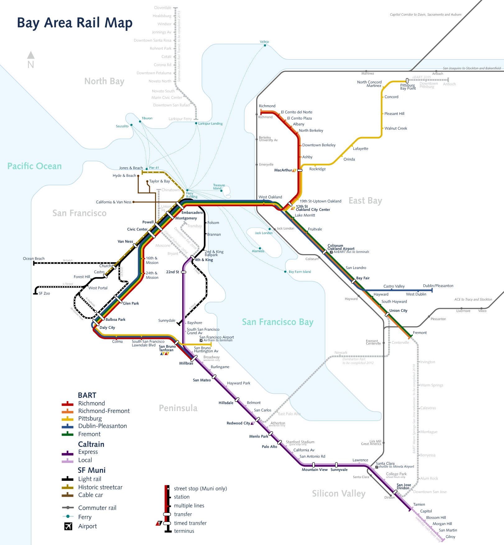 | 1.621 × 1.750 (152 KB) | CountZ | Cropped the file and adjusted ferry connections. | |
| 23:50, 26. Apr. 2009 |  | 1.950 × 1.950 (172 KB) | CountZ | legibility adjustments | |
| 17:49, 26. Apr. 2009 |  | 2.010 × 2.010 (220 KB) | CountZ | Shrunk the file and enlarged the text size | |
| 17:40, 26. Apr. 2009 |  | 3.000 × 3.000 (300 KB) | CountZ | {{Information |Description={{en|1=Map of the San Francisco Bay Area's rail and rapid transit network.}} |Source=Own work by uploader |Author=CountZ |Date= |Permission= |other_versions= }} San Francisco Bay Area, CA <!--{{ImageUpload|full}} |
Dateiverwendung
Keine Seiten verwenden diese Datei.
Globale Dateiverwendung
Die nachfolgenden anderen Wikis verwenden diese Datei:
- Verwendung auf en.wikipedia.org
- Verwendung auf ja.wikipedia.org