
Yoder, Kansas
Yoder, Kansas | |
|---|---|
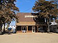
 Hardware & Lumber (2014) | |
 | |
 Yoder  Yoder | |
| Coordinates: 37°56′54″N 97°52′34″W / 37.94833°N 97.87611°W[1] | |
| Country | United States |
| State | Kansas |
| County | Reno |
| Founded | 1889 |
| Area | |
• Total | 37.6 sq mi (97.5 km2) |
| • Land | 37.2 sq mi (96.5 km2) |
| • Water | 0.4 sq mi (1.0 km2) |
| Elevation | 1,539 ft (469 m) |
| Population | |
• Total | 194 |
| • Density | 5.2/sq mi (2.0/km2) |
| Time zone | UTC-6 (Central (CST)) |
| • Summer (DST) | UTC-5 (CDT) |
| ZIP code | 67585 |
| Area code | 620 |
| FIPS code | 20-80775 [3] |
| GNIS feature ID | 0473647 [4] |
| Website | YoderKansas.com |
Yoder is an unincorporated community and census-designated place in Reno County, Kansas, United States. It is located approximately 10 miles southeast of the city of Hutchinson on K-96. As of the 2010 census, the CDP population was 194.[2] Although Yoder is unincorporated, with no city government, it does have a U.S. Post Office and its own ZIP code (67585). Yoder is the hub of a local Amish community and derives its name from its Amish founder.
History
Early history
For many millennia, the Great Plains of North America was inhabited by nomadic Native Americans.
19th Century
The first post office in Yoder was established in November 1889.[5]
20th Century
The community was home to the former Naval Air Station Hutchinson, later renamed to Hutchinson Air Force Station, and currently named as Sunflower Aerodrome Gliderport.
Area events
Yoder Heritage Day takes place annually on the 4th Saturday in August.[6]
Climate
The climate in this area is characterized by hot, humid summers and generally mild to cool winters. According to the Köppen Climate Classification system, Yoder has a humid subtropical climate, abbreviated "Cfa" on climate maps.[7]
Gallery
-
 Looking south down Main Street, in 2010
 -
 Demelia's Quilt Co
 -
 Discount Grocery


References
- ^ Geographic Names Information System (GNIS) details for Yoder, Kansas; United States Geological Survey (USGS); October 13, 1978.
- ^ a b "2010 City Population and Housing Occupancy Status". U.S. Census Bureau. Archived from the original on July 21, 2011. Retrieved March 27, 2011.
{{cite web}}: Unknown parameter|deadurl=ignored (|url-status=suggested) (help) - ^ "American FactFinder". United States Census Bureau. Archived from the original on September 11, 2013. Retrieved January 31, 2008.
{{cite web}}: Unknown parameter|deadurl=ignored (|url-status=suggested) (help) - ^ "US Board on Geographic Names". United States Geological Survey. October 25, 2007. Retrieved January 31, 2008.
- ^ "Kansas Post Offices, 1828-1961". Kansas Historical Society. p. 2. Retrieved June 22, 2014.
- ^ Yoder Heritage Day
- ^ Climate Summary for Yoder, Kansas
Further reading
External links
- Community of Yoder
- Yoder Heritage Day.
- "Yoder Amish Settlement". Amish State Guide.
- Reno County Maps: Current, Historic, KDOT
Municipalities and communities of Reno County, Kansas, United States | ||
|---|---|---|
| Cities |  | |
| CDP | ||
| Unincorporated communities | ||
| Ghost town |
| |
| Townships | ||