
Module talk:Iraqi insurgency detailed map
| This is the talk page for discussing improvements to the Iraqi insurgency detailed map module. |
|
| Archives: 1, 2, 3, 4, 5Auto-archiving period: 30 days |
Template:Syrian Civil War sanctions
| This module does not require a rating on Wikipedia's content assessment scale. It is of interest to multiple WikiProjects. | |||||||||||||||||||||||||||
| |||||||||||||||||||||||||||


| This is the talk page for discussing improvements to the Iraqi insurgency detailed map module. |
|
| Archives: 1, 2, 3, 4, 5Auto-archiving period: 30 days |
Hit
http://rudaw.net/english/middleeast/iraq/100420161 States town is still being fought over and should be changed to contested.
Please Add Roads to the maps of Irak, syria, etc
Following the news about civil war in Irak and Syria, we hear about important roads and Highwys. But we don't see them on the maps to get better oriented. Please someone add roads and highways also to the maps. Thanks! In Persian: با دنبال کردن خبر ها در باره ی جنگ درونمرزی در عراق و سوریه و .. ما همواره چیزهایی در باره ی راه ها و شاهراه های مهم میخوانیم ولی آنهارا در نقشه پیدا نمیکنیم و نمیتوانیم جا های یاد شده را بهتر بیابیم. پس خواهشمندم که راه ها و شاهراه هارا هم به این نقشه ها بیفزایید. سپاس.
Why Husaybah is red?
I really don't think, that Husaybah on the iraqi-syrian border is in the hands of the government... please put it back to black. In some news, there are reports about some explosions due to the rain in a certain town called Husaybah al-Scharqiyah ("East-Husaybah" - not eastern Husaybah), but it is surely not Husaybah on the border and surely not in possession of government. http://altaghier.tv/2015/10/29/الامطار-تفجر-35-بيتا-ملغما-وعشرات-العبوا
Page date is out of date in Template "Iraqi insurgency detailed map"
It is not clear whether "Page Date" applies to the map itself, but otherwise the map is undated. It is important to know the "as of" of the map. It is best not to have to resort to the Archives to guess at the "official" date. Note: Since the status of all locations cannot be realistically know in "real time," there is obviously some art to picking a date, if date of last entry is not deemed "best." --- Thanks, PNA
Fallujah Clashes done
The clashes in Fallujah city are done, and Daesh controls the city: https://www.washingtonpost.com/world/middle_east/is-the-islamic-state-losing-its-grip-on-fallujah/2016/02/20/c86adda2-7416-4cb8-9be5-4ec5d30d3882_story.html
Please change the city to black.
Garma is ISIS-held
Garma (northeast of Fallujah) is ISIS-held based on a report from the reliable Institute for the Study of War: "...the sub-district Garma in eastern Anbar remains under ISIS control". It couldn't be any clearer than that. Garma should be changed from red to black.
Kabisa
Kabisa (or Kubaysah) near Hit in Al Anbar is controlled by IS and is not encircled.
Roads
Adding the major roads/highways might be a good idea
Clashes in Iran between kurdish forces and the Iranian army near the border of Iraq
Hello mappers,
there are reports ([1]) about clashes between Kurdish forces (either from the Kurdish Democratic Party of Iran or from the PKK-linked PJAK) and the Iranian army in villages near the town Sardasht in Iran near the border to Iraq. Shall we maybe add this situation to the map? Similiar things have already been done in the Template:Yemeni Civil War detailed map, where some Saudi-Arabian border towns are also included into the map.
What are your opinions?--Ermanarich (talk) 22:57, 4 May 2016 (UTC)
Great Source on Daesh activities
Hello,
although I didn't get any comments in the talk page here, I hope that some editors read my comments. While researching for the situation in some villages northeast of Mossul I discovered a great page on Daesh/ISIL activities in Iraq.
http://www.daeshdaily.com/2016/04/
I was first a bit confused because of the name, but it's definitely not pro-ISIL. The updates are made on a daily basis and are very detailed.--Ermanarich (talk) 12:27, 5 May 2016 (UTC)
Vandalism southeast of Mosul
So according to the user with the cyrillic name, Daish controls several villages northeast of Gwer? Reliable source lcarabinier reports that Peshmerga controls these villages, not Daish. The vandal with the turk name added these villages as kurd-held, and now russian vandal changes them all to Daish. If I add small villages east of Kirkuk with no source, will he change them to Daish-held? This is crazy, he should be reverted.
source here https://imagopyrenaei.files.wordpress.com/2016/05/5m-syria-iraq-kurdistan.png
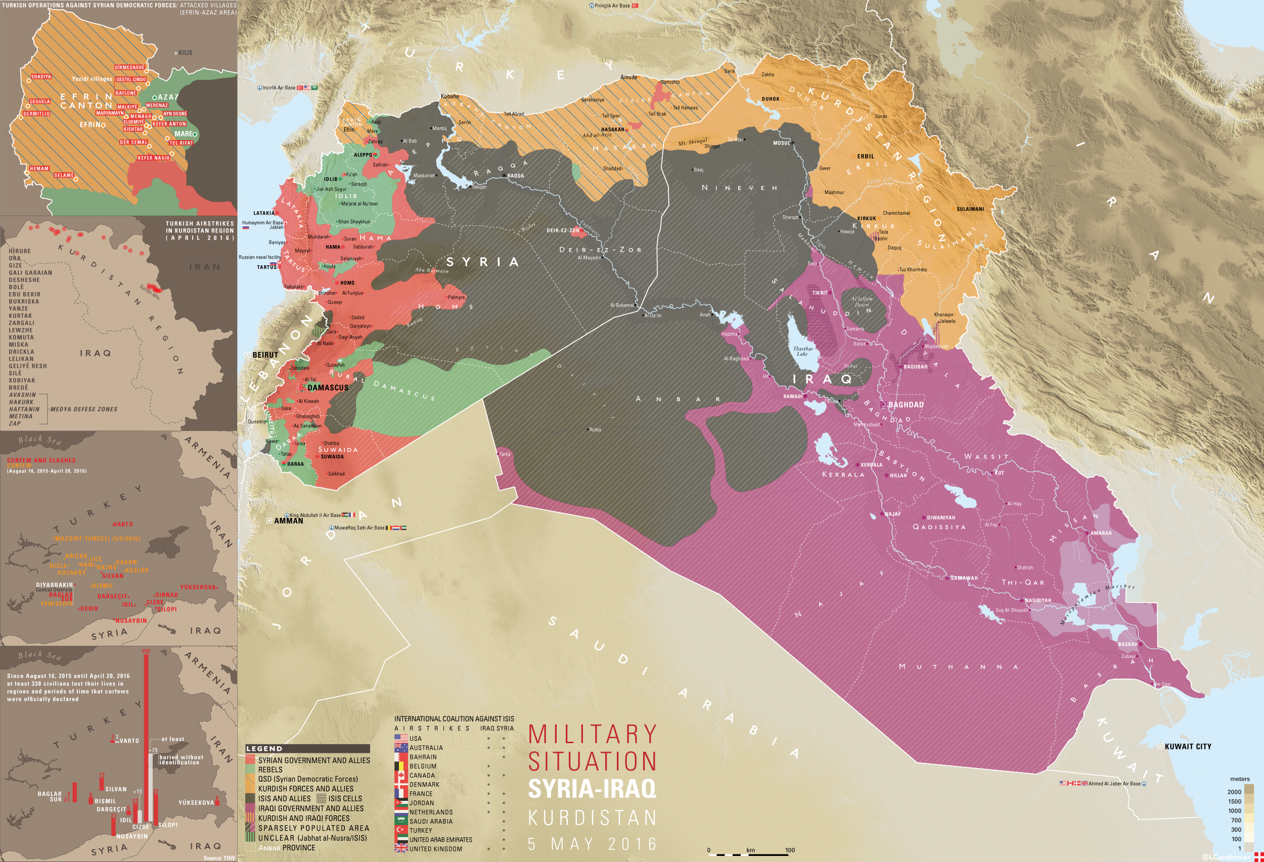
No, it was me who edited it, after this source (http://rudaw.net/english/middleeast/iraq/040520161), which is definitely reliable since it's a kurdish newspage and the article is based on an interview with a Peshmerga official
But if Abu Sheeth village in the articles below is the same as Abu Shitah in the article before, the Rudaw article may just have a translation error: http://www.daeshdaily.com/may-4-2016/ http://www.daeshdaily.com/may-3-2016/ If so, I would change the colours there back to yellow. What do you (who ever wrote it, since there is no signature) think?--Ermanarich (talk) 12:16, 7 May 2016 (UTC)
What I should also mention: Maps do not count as sources for the Wikipedia map in any way!--Ermanarich (talk) 12:17, 7 May 2016 (UTC)
It would be good to discuss it out what we can do with the villages around Abu Shitah. I'm pretty sure that it's the same village as Abu Sheeth, which means that it's in the hands of Peshmerga.
However, it's sure that the village has been attacked by ISIL-militants. That's problematic, because the area around Abu Shitah is isolated from the other territory held by Daesh, since it's east of the Zab river and the bridge in Gwer is definitely held by the Peshmerga, as well as the bridges further to the north.
This means, that ISIL must have some positions near Abu Shitah.
How can we show this on the map, since we don't know them?--Ermanarich (talk) 20:09, 8 May 2016 (UTC)
Kata'eb al-Mosul
Hello,
There seems to be a paramilitary underground organisation called Kata'eb al-Mosul operating in sabotage actions and assassinations against Daesh in Mosul: http://www.daeshdaily.com/may-13-2016/ (and there are actually almost daily mentions about attacks from them at this page)
I think I'll create an article about them soon, but how would you show them on the map? It think to mark Mosul as contested would be highly exaggerated. But do we have other options to show them?--Ermanarich (talk) 14:17, 14 May 2016 (UTC)
- Idon't think it's worth mentioning. Daish controls all of the city and surroundings, so it would be like trying to show rebel presence in al-Mayadin or Raqqa in Syria, for example. In any city taken by group like Daish, there will be underground organizations. It would be different if they seize control of several neighborhoods like Polish Home Army did in Warsaw in 1944, but that has not happened here. If it does, you can mark Mosul as contested.
Mosul village taken, should be marked on map
National Mobilization seize village from Daish near Mosul: https://twitter.com/LCarabinier/status/731549627175043072
Thanks!--Ermanarich (talk) 23:35, 14 May 2016 (UTC)
- The question is if they are keeping control of it, or giving the village to Peshmerga. Kanuni is a Yazidi Kurdish village. The only reason for them being at this front is to train them, so they later can participate in the Mosul offensive. So if any of you can find a source about who controls it, please share. --Ahmedo Semsurî (talk) 21:11, 16 May 2016 (UTC)
It's actually a Shabak and not a Yazidi village. But there is a interesting comment in the new Daeshdaily report. (http://www.daeshdaily.com/may-16-2016/):
"A Shabak MP says the National Mobilization Forces attacked a Shabak village in Bashiqa, supported by Peshmerga, Turkish troops, and Coalition warplanes, starting early morning on Sunday and withdrawing in the afternoon. He says the NMF cannot hold ground, and have destroyed 3 other villages the same way, as their method of attack is to attack without the firepower to maintain control, and then retreat. He says this is part of a plan to change the demography of Shabak, Christian, and Yazidi villages."
And adding a comment: "DaeshDaily comment. This is a rather wild statement, and we are in no way trying to validate it, only to report what the gentleman said."
I'm a bit unsure what we should do with this village now...--Ermanarich (talk) 21:25, 17 May 2016 (UTC)
- Yesterday, the village was retaken by Daesh forces.
- "DaeshDaily comment. This is the same village the NMFs claimed to have “liberated”. Now the statement of the Shabak MP we reported yesterday seems more understandable. He said the NMFs do nothing but allow Daesh to destroy minorities’ villages and then flee when Daesh takes the villages back."
- Seems to be a dirty tactic of the definitely sectarian and often brutal PMFs. A shame, let's hope that the Peshmerga will be soon able to retake the village from Daesh.--Ermanarich (talk) 15:12, 18 May 2016 (UTC)
Tuz Khurmatu & Bashir
Both Tuz Khurmatu and Bashir should be changed to joint yellow/red. Tuz Khurmatu is controlled by local pro-Peshmerge and pro-Iraqi militia/police. Bashir is controlled by Peshmerge and Hashd. But in recent hours large numbers of Hashd are withdrowing from Bashir towards baghdad. Roboskiye (talk) 10:53, 17 May 2016 (UTC)
- It's not true. Btw stop vandalizing the Module.[1][2] Beshogur (talk) 14:30, 17 May 2016 (UTC)
MAP
https://imagopyrenaei.files.wordpress.com/2016/05/shingal-front-forces.png
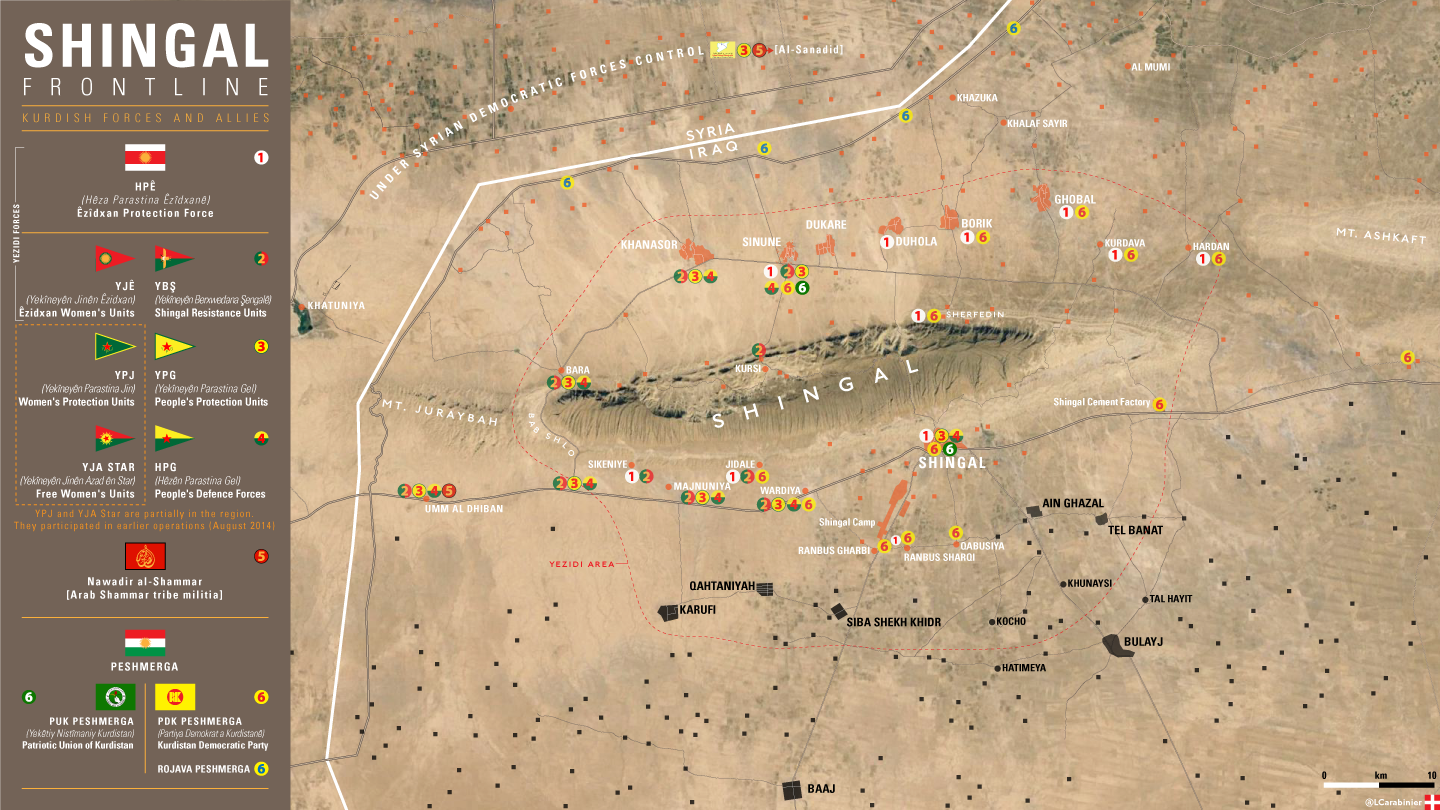
Shingal Map
Important some areas of map are incorrect according reliable source LCarabinier: https://imagopyrenaei.files.wordpress.com/2016/05/shingal-front-forces.png