
User:Unbuttered Parsnip/sandbox
Island group
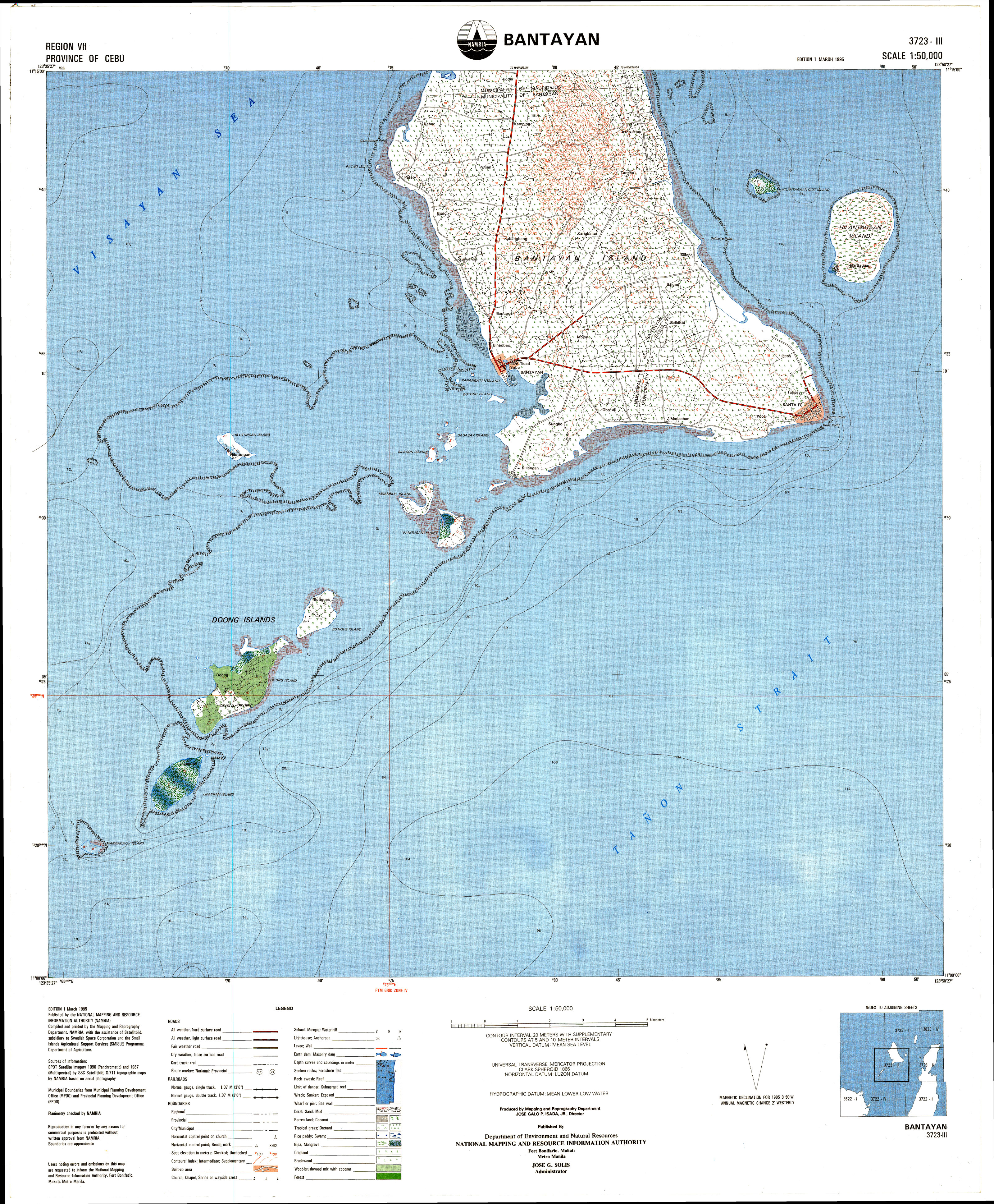
Bantayan is the main and largest island of the Bantayan island group that lies close to the geographical centre of the Philippine Islands archipelago.
The island group includes numerous smaller islands (some uninhabited / uninhabitable), mostly around the southwest corner of the island. About 20 of these islets stretch for about 8 kilometres (5 miles) southwest from Bantayan municipality port area, with some nearer ones being accessible on foot from the main island at low tide. The islands are beside the busy shipping lanes for ships and ferries coming from Mindanao or Cebu City on their way to Manila. The islands are all small and green and low, virtually indistinguishable one from another.
Some of the more notable are:[a]
- B
Botique (or Botigues, Batquis) 2704 - Botong
- Byagayag Islands (Daku and Diot)
- Doong
- Hilantagaan (or Jicantangan, Jilantagaan, Cabalauan)
- Hilantagaan Diot (or Silion, Pulo Diyot (little island))
- Hilutungan (or Hilotongan, Lutungan)[b]
- L
Lipayran 3067 - Mambacayao (or Mambacayao Daku)
- Moambuc (or Maamboc, Moamboc, Kangka Abong, Cangcabong)
- Panangatan (or Pintagan)
- Panitugan (or Banitugan)
- Patao (or Polopolo)
- Sagasay (or Sagasa, Tagasa)
- Silagon
- Yao Islet (or Mambacayao Diot)
- 'These Bantayan islets are numerous, and are all low and very small.' —Juan de Medina (1630)
-
 5 Hilantagaan Island seen from the Santa Fe–Hagnaya ferry (S)
 -
 6 Hilantagaan Dyot, brgy Hilantagaan, Santa Fe, seen from W.
 -
 7 Sunset over Hilutungan, seen from E.
 -
 13 Patao island (or Polopolo) off Patao, Bantayan


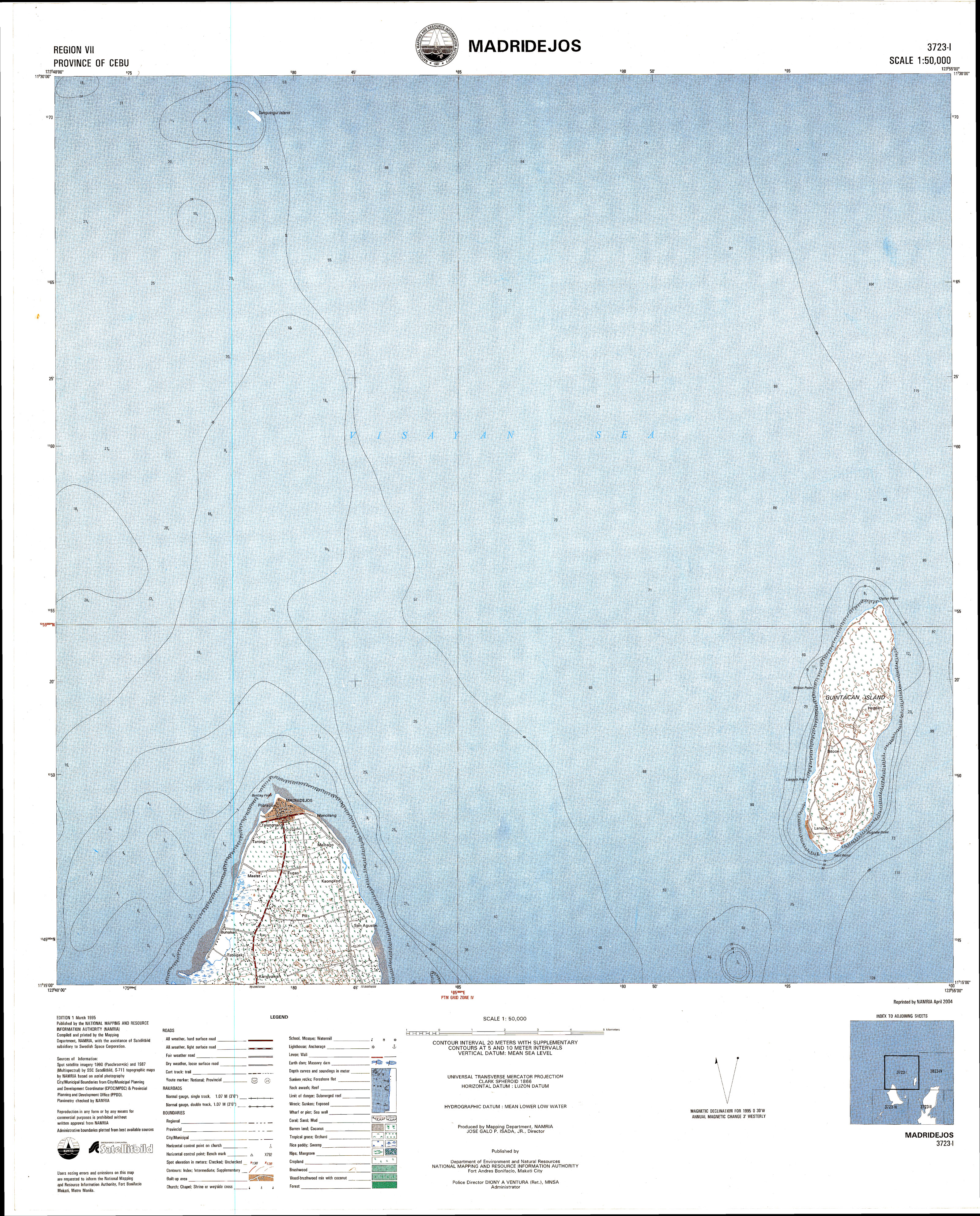
In addition, Guintacan Island (or Kinatarkan, Batbatan) to the NE is part of Santa Fe municipality although it is not part of the Bantayan islands group.
- ^ [Topographic Index Map 1:50,000 NTMS (National Topographic Map Series)] (Digitised map) (Map) (1 ed.). 1:50,000. Cartography by SPOT satellite imagery 1990 (Panchromatic) & 1987 (Multispectral) by SSC Satellitbild / S‑117 topographic maps by NAMRIA based on aerial photography. Fort Bonifacio, Manila: National Planning and Resource Information Authority. March 1995. § 3723‑I Madridejos and 3723‑III Bantayan. Retrieved 24 February 2013.
{{cite map}}: Check|url=value (help); External link in|publisher=and|section= - ^ Cite error: The named reference
proc1801was invoked but never defined (see the help page).
Cite error: There are <ref group=lower-alpha> tags or {{efn}} templates on this page, but the references will not show without a {{reflist|group=lower-alpha}} template or {{notelist}} template (see the help page).